International Defense Security & Technology Your trusted Source for News, Research and Analysis
Related Articles
In an era defined by cutting-edge technology, satellites have emerged as the guardians of the skies, revolutionizing the way we monitor and track moving targets. Beyond their military applications, satellites play a crucial role in various domains, from disaster management to environmental monitoring. This article delves into the realm of satellite technology, exploring how these celestial sentinels enhance military target tracking and extend their watchful gaze to benefit humanity in numerous ways.
A Glimpse into Satellite Technology
Satellites, also known as artificial satellites or space satellites, are man-made objects designed to orbit the Earth or other celestial bodies. Equipped with advanced sensors and communication systems, they serve as our eyes in the sky, providing vital information from space. These remarkable machines come in various shapes and sizes, designed to cater to specific purposes, including Earth observation, communication, navigation, and scientific research.
Conventional Situational Awareness Platforms
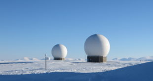
Situational awareness of potential hostile targets and of friendly forces is considered to be a key component in obtaining and sustaining military superiority over adversaries. Airborne Early warning and control (AWACS) aircraft provides a real-time picture of friendly, neutral, and hostile air and maritime activity under all kinds of weather and above all kinds of terrain. Information collected by AWACS can be transmitted directly from the aircraft to other users on land, at sea or in the air. In air-to-air combat, AWACS systems can communicate with friendly aircraft, extend their sensor range and give them added stealth, since they no longer need their own active radar to detect threats.The US E3 AWACS has proved to be a key to victory for the United States in the 1991, 2001, and 2003 campaigns.
JSTARS is a joint development project of the US Air Force and Army which provides a picture of the ground situation equivalent to that of the air situation provided by AWACS. Operating from a stand-off position often in excess of 200 km, it can detect, locate and classify tracks and can target potentially hostile ground movement in all weather. It relays tactical pictures via secure data links to air force command posts, army mobile ground stations and centres of military analysis far from the point of conflict and also functions as battle management, command and control aircraft.
Aging aircraft and the evolving threat landscape from high-end adversaries have sparked a growing interest in the feasibility of using satellites to complement existing surveillance efforts. These aircraft are aging and are increasingly considered unable to survive in the Highly Contested Environments (HCEs) that could be created by high-end adversaries.
Wide-body aircraft like the E-3 Sentry (AWACS) and E-8C Joint STARS have long been instrumental in providing dynamic targeting and engagement of air and surface targets. However, concerns about their survivability in HCEs have led the Air Force to consider innovative solutions that combine the advantages of aircraft and satellites.
Enhancing Military Target Tracking
One of the most critical applications of satellite technology lies in military target tracking. Satellites equipped with sophisticated imaging systems, such as Synthetic Aperture Radar (SAR) and electro-optical cameras, empower defense forces to monitor the movements of potential adversaries with unmatched precision and real-time updates.
Here’s how satellites enhance military target tracking:
a. Persistent Surveillance: Unlike traditional surveillance methods, which may have limitations due to line-of-sight or physical barriers, satellites offer persistent global coverage. They can observe vast regions and relay valuable data without being hindered by geographic obstacles, making them ideal for monitoring remote or inaccessible areas.
b. All-Weather Capability: Satellite-based tracking systems are not dependent on weather conditions. Whether it’s a bright, sunny day or a stormy night, satellites can peer through clouds and darkness to capture crucial information, ensuring continuous surveillance and strategic advantage.
c. Discreet Operations: Satellites can conduct surveillance discreetly from space, minimizing the risk of detection or interception by the targeted entities. This stealthy approach allows defense forces to gather intelligence covertly, a key advantage in modern warfare scenarios.
d. Intelligence Fusion: By integrating data from various sources, including electronic intelligence (ELINT) and signals intelligence (SIGINT), satellites provide a comprehensive intelligence picture. This fusion of data enhances the accuracy and reliability of the information collected, enabling better decision-making and threat assessment.
Tracking ground targets from Satellites
Satellite tracking of moving targets and ground moving objects is an essential tool for a wide range of applications. The ability to monitor the location and movement of objects from space is crucial for military surveillance, transportation monitoring, and weather forecasting, among other uses.
To track moving targets, various techniques and methods are utilized, such as passive radar, synthetic aperture radar (SAR), optical imaging, and GPS tracking. Passive radar relies on the reflection of signals from other sources, such as commercial radio or TV stations, to detect and track moving objects, such as aircraft or ships.
SAR, on the other hand, uses the motion of the satellite to create high-resolution images of the Earth’s surface and can be used to track moving objects by comparing multiple images over time. Optical imaging, the use of cameras and sensors, can also be used to track moving objects by comparing images over time. Videos captured byAircrafys and UAV platforms usually have a high resolution with rich appearance, but with a fixed and limited spatial coverage (i.e., the field of view). In contrast, cameras mounted on satellites can provide spatial-temporal surveillance over a large-scale area which is suitable for the task of urban-scale traffic management, ocean monitoring, and smart city.
With the great success of data-driven deep neural networks, remarkable progress has been achieved in the area of video understanding in recent years. However, achieving accurate and robust moving object detection and tracking in satellite videos is a high challenge task due to the following reasons: First, there is a lack of high-quality and well-annotated public datasets and comprehensive benchmarks. It is non-trivial to evaluate the performance of different algorithms in a fair and comprehensive way, especially for multi-object tracking in satellite videos. Second, satellite videos usually have a lower spatial resolution than generic videos.
The scales of objects are very small (usually less than 50 pixels), but with large quantities (even more than 100 in a single frame). This is inherently different from generic videos captured by commercial cameras, where the objects of interest usually have rich appearance information and limited numbers in a single frame. Finally, the background in satellite videos is more complex (with all elements in a city such as rivers, buildings, dense lanes) and continuously-changing (e.g.,
illumination variations), due to the unique viewpoint and the large field of view of the platform. Consequently, these issues pose great challenges to existing methods trained on generic videos.
GPS tracking is a technique that utilizes a network of GPS satellites to determine the position of an object on the Earth’s surface, which can be used to track the movement of vehicles or other objects equipped with GPS receivers.
In tracking ground moving objects from satellites, several methods are employed, including optical imaging, SAR, infrared imaging, GPS tracking, and the automatic identification system (AIS). Optical imaging, as mentioned earlier, uses cameras and sensors to capture images of the Earth’s surface to track ground moving objects, such as vehicles or ships.
SAR, on the other hand, is a type of radar that uses the motion of the satellite to create high-resolution images of the Earth’s surface and can be used to track ground moving objects.
Infrared imaging detects the thermal radiation emitted by objects on the Earth’s surface, which can be used to track the heat signature of ground moving objects such as vehicles.
GPS tracking is a technique that uses a network of GPS satellites to determine the position of ground moving objects equipped with GPS receivers, such as vehicles or mobile devices.
Lastly, AIS is a system used by ships and boats to broadcast their location and other information to other vessels and to shore-based stations, which can be received and processed by satellite to track the location and movement of ships and boats.
Overall, the combination of these techniques provides highly accurate and detailed information about the location and movement of moving targets and ground moving objects from satellites. This information is crucial for a variety of applications, including transportation monitoring, border security, and disaster response, among others.
Tracking Air targets from satellites
Tracking air targets from satellites is a challenging task due to several factors, including the speed and altitude of the target, the distance from the satellite, and the need for high-resolution imaging or radar capabilities. Nevertheless, advances in satellite technology have made it possible to track air targets from space.
One of the most common methods for tracking air targets from satellites is through the use of synthetic aperture radar (SAR) technology. SAR uses the motion of the satellite to create high-resolution images of the Earth’s surface, including airborne objects, by sending out radar signals and analyzing the reflected signals. This technique is particularly useful for tracking aircraft and other flying objects, as it can detect small changes in position and velocity.
Another technique used for tracking air targets is optical imaging, which involves the use of cameras and sensors to capture images of the Earth’s surface, including airborne objects. Optical imaging can provide valuable information about the speed, altitude, and direction of the target, but it requires clear weather conditions and a relatively low altitude for the satellite.
In addition to SAR and optical imaging, other techniques used for tracking air targets from satellites include electronic intelligence (ELINT) and signals intelligence (SIGINT). These methods involve intercepting and analyzing the electronic signals emitted by the target, such as radar or radio signals, to determine its location, speed, and other characteristics.
Air Force advisers study use of satellites for tracking moving targets
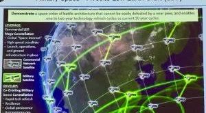
In an era where advanced technology shapes modern warfare, the United States Air Force is exploring new possibilities to enhance its capabilities in tracking moving targets. Traditionally relying on wide-body aircraft with Moving Target Indication (MTI) radars, the Air Force is now turning its attention to space-based systems as an alternative means to support operations in Highly Contested Environments (HCEs).
Satellite technology offers unique benefits for surveillance and targeting, such as persistent global coverage, all-weather capabilities, and discreet operations. These advantages make space-based systems increasingly appealing in modern military operations. While space-based radar and electro-optical sensors can effectively generate imagery of stationary targets, tracking moving targets from Low Earth Orbit (LEO) presents its challenges.
It requires near-continuous target coverage, which necessitates the deployment of highly proliferated constellations, potentially consisting of hundreds or even thousands of satellites. This poses both technical and cost challenges, making previous efforts to develop Moving Target Indication (MTI) Space-Based Radar (SBR) systems less successful. The landscape of satellite technology is rapidly evolving, with commercial efforts driving down the cost of LEO satellite constellations.
Increasing numbers of satellites are being proposed and launched, enhancing the feasibility of using satellites for military applications. Moreover, innovative sensing approaches and concepts are being explored at the individual satellite and system levels, offering potential cost reductions. To assess the feasibility of incorporating aircraft and satellites to track moving targets in HCEs, the Air Force’s Scientific Advisory Board has been tasked with an independent assessment.
The study will examine the necessary requirements for a future MTI capability and address the associated risks and challenges of using satellites and space-based radars alongside aircraft for this mission. Space-based radar and electro-optical sensors can generate imagery of stationary targets. However, tracking moving targets from Low Earth Orbit (LEO) requires near-continuous target coverage and hence highly proliferated constellations (hundreds of satellites).
In the pursuit of a more advanced and adaptable military force, the Air Force is exploring multiple avenues. Alongside the MTI assessment, the scientific advisory board is conducting studies on advanced air and space mobility concepts, resilient air operations, and improvements in the Air Force’s testing enterprise. The study of utilizing satellites for tracking moving targets represents a promising step toward modernizing the Air Force’s surveillance and targeting capabilities.
By leveraging the strengths of both aircraft and satellites, the Air Force aims to achieve enhanced situational awareness and strategic advantage in HCEs. As commercial advancements continue to drive down satellite costs and innovative technologies emerge, the vision of an integrated and efficient system incorporating aircraft and satellites draws closer to becoming a reality. With insights from the Scientific Advisory Board’s study, the Air Force can chart a path towards a more secure and prepared future.
According to a recently released study outline, the service tasked its scientific advisory board with assessing the feasibility of using both aircraft and satellites in low Earth orbit, about 1,200 miles (2,000 kilometers) above the planet surface, to track moving targets.
“Current commercial efforts are driving down the cost of proliferated LEO satellite constellations with constellations comprised of thousands of satellites proposed and hundreds already launched,” the study outline states. “In addition, alternative sensing approaches and innovative concepts, at the individual satellite level and at the overall systems level, may help to drive down the cost of satellites.”
Along with the MTI assessment, the scientific advisory board is pursuing three other studies in fiscal 2021 that will explore advanced air and space mobility concepts, development and operational testing approaches, and resilient air operations. The board will brief Air Force Secretary Frank Kendall on its findings in each topic area in July and publish reports in December.
The air and space mobility study will focus on how concepts like autonomous refueling, space cargo transport and innovative tanker designs could improve mobility in a future war with China.
“Due to the wide geographic expanses and limited basing availability in the Pacific, increasing Combat Air Force reliance on distant bases will place increased demands for aerial refueling offload,” the study description states. “Similarly, base resilience concepts including Agile Combat Employment and reduced runway dependence will rely heavily on inter-theater and intra-theater airlift for deployment and sustainment.”
The board will assess the Air Force’s tanker and airlift capabilities and shortfalls and recommend science and technology investments in those areas.
For the resilient air operations study, the service wants the board to assess current threats to bases in the European and Pacific regions and consider options for air defenses that have a “favorable cost exchange ratio.” Air Force wants a review of a range of technologies, including directed energy weapons, lasers, non-kinetic interceptors and “runway independent aircraft technologies.”
The study will:
The study will survey technology advances like artificial intelligence and modeling and simulation that could improve the Air Force’s testing enterprise. It will also identify technology and process issues in the service’s approach.
• Survey and assess requirements for surveillance and targeting data for air and surface targets
in HCEs during peacetime, crisis, and wartime conditions. Consider concepts of employment similar to those used with AWACS and Joint STARS but also new approaches.
• Survey and assess needed sensor and platform capabilities and quantities to provide the
required data.
• Assess technology availability, risks and cost to develop the needed capabilities, including
consideration of innovative approaches.
• Review supporting systems and technologies, including tasking and sensor resource
management, communications systems to distribute and disseminate data, and tracking
and fusion systems to combine data from individual satellites.
• Assess countermeasures, electromagnetic and physical to sensing systems.
• Propose science and technology investments needed in the near-, mid- and far-term to develop
and deploy MTI systems.
The board’s testing study is geared toward ensuring the Air Force’s processes for assessing new capabilities is moving quickly and efficiently.
“In an era of competition with China, which is developing and introducing new operational capabilities at a high rate, there is concern that the [developmental and operational testing] enterprise is not helping to provide operational capabilities rapidly enough to adapt to the changing technological and competition environment,” the outline states.
Overall, tracking air targets from satellites is an important capability for military and intelligence agencies, as it provides valuable information about airborne threats and can be used for surveillance, reconnaissance, and other applications. While there are challenges associated with tracking air targets from space, advances in satellite technology continue to improve the accuracy and effectiveness of these capabilities.
Beyond the Battlefield: Satellite Applications for Humanity
While military target tracking is a crucial aspect of satellite technology, the reach of these celestial guardians extends far beyond the battlefield. Satellites have become indispensable tools for addressing global challenges and improving the quality of life on Earth:
a. Disaster Management: During natural disasters such as earthquakes, hurricanes, or wildfires, satellites play a pivotal role in disaster management. They provide real-time imagery of affected regions, aiding rescue operations, and assessing damage to infrastructure, which helps in coordinating relief efforts efficiently.
b. Environmental Monitoring: Satellites contribute significantly to environmental protection and monitoring. They track deforestation, changes in land use, and measure greenhouse gas emissions, providing invaluable data for understanding climate change and implementing conservation measures.
c. Weather Forecasting: Advanced weather satellites observe atmospheric conditions, cloud patterns, and ocean temperatures, allowing meteorologists to forecast weather systems accurately. Timely and accurate weather predictions help communities prepare for extreme weather events and mitigate their impact.
d. Communication and Navigation: Communication satellites enable global connectivity by facilitating long-distance communications, including internet access, telephony, and broadcasting. Additionally, navigation satellites, like the Global Positioning System (GPS), have become indispensable for precise location-based services in various sectors, from transportation to agriculture.
Future Frontiers: Space-Based Innovation
As technology advances, the potential of satellite-based applications continues to expand. Emerging trends, such as small satellite constellations and advanced sensor technologies, promise to reshape satellite capabilities in the following ways:
a. Enhanced Data Analytics: With advancements in data analytics and artificial intelligence, satellites will process and analyze vast amounts of data more efficiently. This will lead to quicker insights and decision-making, benefiting various industries and applications.
b. Interconnectivity: As satellite constellations become more interconnected, they will create a web of real-time information, enabling seamless communication and data transfer worldwide.
c. Space Exploration: Satellites will continue to play a critical role in space exploration, supporting missions to other planets and celestial bodies, furthering our understanding of the cosmos.
Conclusion
Satellites have undoubtedly become the guardians of the skies, enhancing military target tracking and providing invaluable contributions to humanity. From improving military surveillance to aiding disaster management and environmental monitoring, the applications of satellite technology are vast and continually evolving. As we venture further into the future, the possibilities are limitless, and the skies above hold the promise of even greater advancements that will shape our world for the better
References and Resources also include: