Digital battlefields, hybrid warfare, and the future of threat intelligence
IDST Intelligence Briefings
(Latest Security & Cyber Videos)
Why This Magazine Exists
Security, Cyber & Counter-Threats examines the evolving landscape of modern security in an era defined by digital conflict, hybrid warfare, and persistent global threats.
From cyber operations, information warfare, and intelligence-driven defense to counter-terrorism, internal security, and emerging threat vectors, this magazine provides strategic analysis, technical insight, and policy-relevant perspectives for decision-makers, practitioners, and researchers navigating an increasingly contested security environment.
What We Track
- Cyber warfare & cyber defense
- Information operations & influence campaigns
- National security threat assessments
- Emerging digital and hybrid warfare doctrines
- Critical infrastructure & cyber resilience
Latest Analysis & Intelligence
-
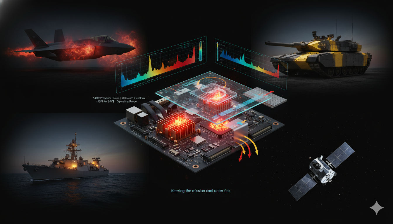
Beating the Heat: How Advanced Thermal Management Is Enabling Mission-Critical Systems Across Land, Sea, Air, and Space
Thermal management has quietly become one of the most decisive enablers of modern military power. As defense systems transition toward high-density electronics, artificial intelligence workloads, and high-energy weapons, heat is no longer a secondary engineering concern—it is a primary constraint on performance, survivability, and mission endurance. In platforms ranging from hypersonic glide vehicles and fifth-generation…
-

The Green Bunker Revolution: How Epoxy Bamboo Composites Are Transforming Military Infrastructure
Introduction: Rethinking Protection at the Edge of War From the icy heights of the Himalayas to the dense jungles of Southeast Asia, the future of military infrastructure is being quietly reengineered—not with steel or concrete, but with biology enhanced by advanced materials science. As modern warfare increasingly shifts to extreme and logistically constrained environments, the…
-

Single-Photon Detectors: The Quantum Eye Powering Computing, Communications, Defense, and Particle Physics in 2026
Introduction: Seeing the Smallest Signal The ability to detect extremely faint light has become one of the defining technological capabilities of the modern era. Whether enabling secure quantum communications, guiding autonomous vehicles, imaging biological processes, tracking hypersonic objects, or probing the structure of matter itself, sensors that can register individual photons are increasingly central to…
-

Rewriting the Code of Life: How Genomically Recoded Organisms Are Ushering in a New Era of Biotherapeutics
For more than three billion years, nearly every organism on Earth has used essentially the same genetic operating system. DNA stores information in four chemical letters, ribosomes read that information three bases at a time, and proteins are assembled from a standard alphabet of twenty natural amino acids. Modern biotechnology has become highly skilled at…
-

Magnetic Fusion Plasma Engines: Propelling Humanity Across the Cosmos
The Plasma Revolution: How Next-Generation Engines Could Slash Travel Times to Mars For more than half a century, space propulsion has been dominated by the chemistry of combustion—powerful, reliable, but fundamentally constrained. Even the most advanced chemical rockets remain bounded by thermodynamics, with exhaust velocities of only a few kilometers per second and mission timelines…
-

Light Over Matter: How Opto-Magnetic Technology Is Rewriting the Future of Data Storage
Reframing the Storage Paradigm in the AI Era The global data ecosystem is entering a phase of exponential expansion, driven by artificial intelligence training, edge computing, and real-time analytics. Conventional storage technologies—whether hard disk drives or even advanced spintronic memory—remain fundamentally constrained by magnetic-field-based writing mechanisms that are energy-intensive, spatially diffuse, and increasingly incompatible with…
-
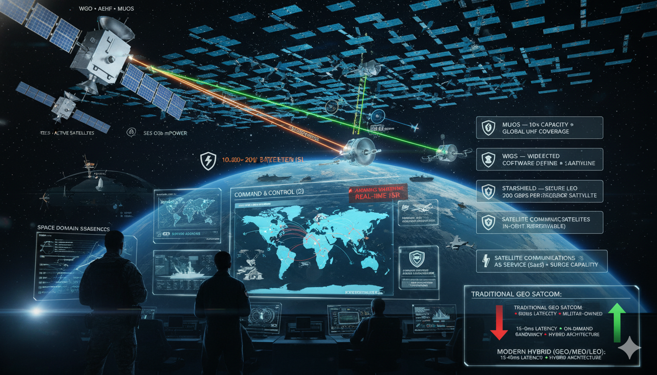
Military Satellite Communication (MILSATCOM): Technology, Trends, and Strategic Imperatives (2026 Update)
Securing the High Ground: How Space-Based Communications Are Reshaping Modern Warfare Executive Summary Military satellite communication (MILSATCOM) has evolved from a supporting enabler into a core warfighting infrastructure layer underpinning modern multi-domain operations. The integration of proliferated Low Earth Orbit (LEO) constellations, software-defined satellites, and hybrid military-commercial architectures has fundamentally transformed global defense communication systems.…
STRATEGIC SUB-MAGAZINES
Modern military power emerges from the interaction of platforms, people, doctrine, and integration across domains. The Defense & Military Systems magazine is structured into focused sub-magazines that examine how combat capability is built, sustained, and employed across air, land, sea, weapons, and human systems.
Cyber & Information Warfare
Industrial outcomes are shaped as much by incentives, policy, and market structure as by engineering. Price signals, investment cycles, and regulatory frameworks quietly determine which technologies scale, stagnate, or fail.
This sub-magazine examines how markets behave under strategic pressure—where capital flows, how demand signals distort decisions, and why some industries adapt faster than others.
Explore the Cyber & Information Warfare Sub-Magazine →
Security & Threat Management
Modern security is defined by persistence, coordination, and anticipation. This sub-magazine focuses on how threats are identified, mitigated, and managed across institutions, infrastructures, and societies.
Explore the Security & Threat Management Sub-Magazine →