 International Defense Security & Technology Your trusted Source for News, Research and Analysis
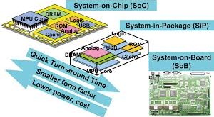
In today’s dynamic and competitive business environment, organizations are under constant pressure to deliver projects …
Read More »

Advancing Camouflage: Military’s Response to Thermal Imaging Threats
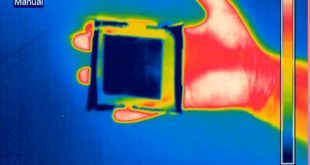
Introduction: In the ever-evolving landscape of modern warfare, the development and deployment of advanced technologies have revolutionized military strategies and tactics. Among these technologies, thermal imaging cameras have emerged as a formidable tool, enabling enhanced visibility and detection capabilities on the battlefield. However, with this increased visibility comes a new …
Read More »