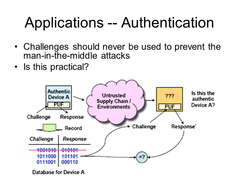
Global Satellite Navigation Systems (GNSS), including the U.S. GPS, Russia’s GLONASS, China’s BeiDou, and Europe’s Galileo, provide real-time positioning, navigation, and timing (PNT) data that are critical for both civilian and military operations. These systems have become indispensable in modern life, with GPS in particular becoming essential to millions of people around the world since its creation in the 1980s.
However, this reliance has become a vulnerability as adversaries develop increasingly sophisticated methods to disrupt these signals through Navigation Warfare (NAVWAR) tactics.
However, this reliance has become a vulnerability as adversaries develop increasingly sophisticated methods to disrupt these signals through Navigation Warfare (NAVWAR) tactics. To maintain operational superiority, defense forces are rapidly developing Counter-PNT systems capable of detecting, resisting, and defeating these threats in contested environments.
With geopolitical tensions rising and the pace of technological advancements accelerating, countries worldwide are realizing the need for more resilient systems that can ensure accurate and uninterrupted navigation. This has sparked a global effort to develop Assured Positioning, Navigation, and Timing (APNT) technologies, designed to counter the growing threat of GPS jamming and the emerging domain of navigation warfare.
GPS: The Backbone of Global Navigation
The GPS constellation consists of 24 satellites that freely deliver positioning, timing, and navigation information globally, with military applications being particularly significant. GPS allows military units, whether in the air, on land, or at sea, to determine their precise position, synchronize operations, and navigate through unfamiliar terrain. Key military applications of GPS include guiding missiles, precision munitions, UAVs, and even soldiers in challenging environments. The Joint Direct Attack Munition (JDAM) system, for instance, uses GPS to achieve remarkable accuracy, allowing bombs to land within 10 feet of their intended target, even from great distances.
However, military operations often occur in environments where GPS signals are either weak or unavailable—such as indoors, in urban canyons, dense foliage, underwater, or underground. Solar storms can also degrade GPS signals, and GPS is highly susceptible to disruption from jamming and spoofing
The Growing Threat: GNSS Vulnerabilities in Modern Warfare
GNSS signals face multiple vulnerabilities that adversaries are actively exploiting. The weak signal strength from satellites makes them particularly susceptible to interference, a weakness that nations like China, Russia, and Iran have been quick to weaponize through electronic warfare systems. These threats manifest in several forms that are reshaping modern battlespaces.
GPS jamming and spoofing refer to malicious actions that disrupt, deny, or manipulate the GPS signals used for navigation and timing. Jamming occurs when unauthorized signals interfere with legitimate GPS signals, rendering them useless or inaccurate. Jamming remains the most common threat, where adversaries overpower legitimate GPS signals with radio frequency noise, effectively blinding receivers across wide areas. More sophisticated spoofing attacks present an even greater danger by broadcasting false GNSS signals that trick navigation systems into into calculating incorrect positions or times. Perhaps most concerning are cyberattacks targeting the PNT infrastructure itself, corrupting the timing data that underpins everything from communications networks to weapons guidance systems.
The Rise of GPS Jamming and Navigation Warfare
Navigation warfare (NAVWAR) is an escalating threat that disrupts and deceives navigation systems using deliberate jamming and spoofing. In modern conflicts, jamming has become a routine tactic, often deployed alongside kinetic capabilities to disrupt enemy operations.
The Russia-Ukraine conflict has provided sobering demonstrations of these tactics in action. oth sides have employed widespread GPS jamming that has degraded drone operations, disrupted precision munitions, and forced adaptations in troop movements. These real-world examples underscore how PNT disruption can level the playing field against technologically superior forces, making Counter-PNT capabilities not just valuable but essential for modern military operations.
Russia’s actions in Ukraine and Syria highlight its advanced electronic warfare (EW) capabilities. For instance, Russian forces have consistently jammed GPS signals in southeastern Ukraine, rendering drones ineffective. Reports from the Organization for Security and Cooperation in Europe indicate that every single drone observing the conflict in eastern Ukraine has been subject to military-grade GPS jamming, demonstrating the strategic use of EW to deny adversaries critical situational awareness.
Russia’s electronic warfare capability, as reported by Jane’s Country Risk Daily Report, includes both permanent installations and mobile EW stations with a disruption radius of up to 80 km. These systems are designed to interfere with Western military communications and surveillance, creating an electronic battlefield where GPS-guided systems are at risk. Similarly, North Korea’s alleged GPS jamming activities affected South Korean air and sea traffic between 2010 and 2013, causing intermittent disruptions and raising regional security concerns about NAVWAR’s potential impact.
One of the critical issues with GPS and GNSS signals is their susceptibility to jamming. GNSS jammers, now used by criminals and military adversaries alike, can disrupt the GPS signals for many kilometers. The U.S. military’s reliance on GPS has made the disruption of these signals a primary goal for adversaries, especially in warfare. John Fischer, Chief Technical Officer for Spectracom, explains, GPS signals are inherently weak and susceptible to even low-power jamming. For instance, a jammer of just 1–10 watts can deny GPS signals across a large area, affecting both military and civilian applications. Although the U.S. military is transitioning from SAASM to the more advanced M-Code, even this new standard cannot fully counter high-powered jamming, a vulnerability that adversaries could exploit in electronic warfare scenarios.
Anti-satellite weapons, GPS jammers, and spoofers are all threats designed to degrade, deny, or destroy the GPS network, forcing military forces to revert to less accurate methods of navigation. This reliance on GPS has led to incidents such as Russia’s GPS jamming during its operations in Syria, which interfered with civilian air traffic in the Eastern Mediterranean.
In addition to jamming, adversaries use GPS-spoofing attacks, where a malicious actor generates GPS-like signals to mislead receivers. Spoofing is technically more complex than jamming but is effective for manipulating targets, especially when GPS receivers lack robust anti-spoofing defenses. To counter this, military systems use secure, encrypted GPS signals like the Selective-Availability Anti-Spoofing Module (SAASM) or M-Code. Other measures, such as combining signals from multiple GNSS constellations and using tightly coupled inertial navigation systems, can also strengthen resilience against spoofing attempts.
These threats have traditionally been associated with military operations, as adversaries attempt to degrade or deny the use of GPS for navigation and targeting. However, the implications of GPS disruptions extend far beyond the battlefield. As civilian sectors, including aviation, shipping, autonomous vehicles, and critical infrastructure, become more dependent on GPS, the impact of jamming and spoofing is becoming increasingly pervasive. GPS interference can cause misdirection, delays, safety hazards, and financial losses. Furthermore, the rise of “navigation warfare”—a term used to describe the intentional disruption of navigational systems—has made the stakes even higher, with nations realizing the potential of using GPS disruption as a strategic weapon.
How Militaries Are Fighting Back
Defense organizations worldwide are implementing multi-layered strategies to maintain PNT resilience against these growing threats. These approaches combine alternative positioning methods with advanced protection technologies and new operational doctrines.
The Need for Assured Positioning, Navigation, and Timing (APNT) Technologies
As global dependence on GPS for critical infrastructure grows, the threat of GPS jamming, spoofing, and other interference has become a serious concern. To address these vulnerabilities, countries are investing heavily in Assured Positioning, Navigation, and Timing (APNT) technologies. These systems are designed to deliver reliable and secure navigation solutions, ensuring accuracy even in contested environments. APNT combines multiple technologies, including multi-constellation GNSS, inertial navigation systems (INS), radar, and other backup systems, to ensure continuous, accurate PNT data. This approach safeguards mission-critical sectors, such as aviation, military, and autonomous systems, from disruptions that could otherwise jeopardize safety and operational continuity. The increasing importance of the electromagnetic spectrum has led the Pentagon to strengthen its electronic warfare policy, integrating EW across all military domains, including NAVWAR.
Approaches to Achieving Assured PNT (APNT)
Assured Positioning, Navigation, and Timing (APNT) goes beyond resilience by ensuring that PNT systems remain reliable and secure, even in the most challenging operational scenarios. The following strategies outline the U.S. military’s efforts to achieve APNT:
Alternative PNT Sources
Military researchers are developing diverse backup systems to reduce dependence on vulnerable GNSS signals. Inertial Navigation Systems (INS) use advanced accelerometers and gyroscopes to maintain positioning through dead reckoning when external signals are lost.
One promising alternative is magnetic navigation (MAGNAV), which relies on variations in the Earth’s magnetic field as a passive and persistent source of orientation and positioning. Because the magnetic field is not externally generated, it cannot be jammed or spoofed, making MAGNAV a powerful tool in denied environments.
Another technique is celestial navigation, which uses onboard optical sensors to track the position of stars and celestial bodies for orientation. While less practical in cloudy or indoor environments, celestial methods offer a viable backup in clear skies or space-based missions. Inertial navigation systems (INS), which use gyroscopes and accelerometers to calculate position based on movement, are also being refined and miniaturized. Though INS tends to drift over time, when fused with periodic GNSS updates or other external signals, it becomes a robust navigation component.
Another promising approach involves terrain-referenced navigation, where radar or LiDAR scans are matched against pre-mapped terrain databases. Perhaps most significantly, new commercial Low-Earth Orbit (LEO) satellite constellations from companies like Xona Space Systems promise to provide GPS-independent PNT services with enhanced security features.
Finally, the use of “signals of opportunity” represents a creative way to repurpose ambient signals—such as radio, TV broadcasts, and cellular signals—as sources for localization and timing. This passive method offers resilience by leveraging the existing electromagnetic environment to extract navigation information without reliance on vulnerable GNSS infrastructure.
Integration of Redundant Systems
A key strategy for achieving assured PNT is the integration of redundant systems that can provide backup positioning and timing data. In addition to GNSS-based solutions, the U.S. military is investing in ground-based augmentations, such as pseudolites, which can generate GPS-like signals in environments where satellite signals are unavailable or unreliable. These backup systems ensure that military operations can continue seamlessly, even in areas where traditional satellite signals are weak or obstructed, such as urban environments or underground locations.
Multi-Constellation and Multi-Frequency GNSS
One of the most effective defenses against interference is the deployment of multi-constellation GNSS receivers. These systems can draw signals from various satellite constellations—such as GPS, Galileo, GLONASS, and BeiDou—allowing for broader coverage and greater signal diversity. This makes it significantly harder for attackers to effectively jam or spoof all available signals simultaneously. Adding multi-frequency capabilities enables receivers to compare and cross-validate signals on different bands, helping to detect discrepancies and preserve navigation integrity in contested environments.
Hybrid PNT Solutions
Hybrid PNT solutions combine multiple technologies, including GNSS, inertial navigation systems (INS), and terrestrial-based systems, to create a more reliable and robust PNT framework. By using multiple sources of data, these hybrid systems can maintain PNT functionality even in the event of signal degradation or system failure. The Army’s ongoing development of hybrid solutions ensures that military systems can achieve assured PNT, regardless of external threats or environmental challenges.
Anti-Jamming & Anti-Spoofing Technologies
To achieve APNT, it is critical to ensure that PNT signals remain secure and cannot be manipulated by adversaries. The military is implementing advanced anti-spoofing technologies that detect and mitigate attempts to falsify PNT data. These technologies include cryptographic techniques and signal authentication mechanisms, which ensure that the PNT data received by military systems is accurate and trustworthy.
Enhanced Signal Authentication
As part of its efforts to assure PNT, the U.S. military is focusing on enhancing signal authentication. This involves verifying that the PNT signals are coming from legitimate sources and not from hostile entities attempting to disrupt operations. One approach involves embedding additional layers of authentication data within PNT signals to confirm their authenticity.
Additionally, digital signal authentication techniques are being developed to verify that a received satellite signal is indeed genuine and unaltered, significantly reducing the threat of spoofing. Meanwhile, machine learning algorithms and artificial intelligence are enabling the creation of systems that can automatically learn and identify abnormal signal behavior, distinguishing between benign fluctuations and malicious interference in real-time.
This added security layer helps prevent malicious interference and ensures that the PNT systems are receiving accurate and trustworthy information.
Advanced Resiliant Systems
Alongside alternative positioning methods, militaries are fielding advanced systems to protect existing GNSS capabilities. Controlled Reception Pattern Antennas (CRPA) represent a major advancement, using sophisticated directional antennas that can filter out jamming signals while maintaining reception of legitimate satellite transmissions.
Beamforming antennas are increasingly employed to focus on receiving genuine GNSS signals while rejecting interference coming from other directions. These antennas use dynamic electronic steering to isolate desired signal paths and suppress jammers.
The military’s new M-Code GPS signals incorporate cryptographic security measures specifically designed to resist spoofing attempts. Perhaps most innovative are AI-powered signal authentication systems that use machine learning algorithms to detect and reject fake GNSS signals by analyzing subtle anomalies in signal characteristics
Integration with Command and Control Systems
Assured PNT also requires seamless integration with military command and control (C2) systems. The Army is working to integrate PNT solutions into its C2 systems to ensure that accurate and real-time positioning and timing information is available across all levels of command. This integration helps military leaders make informed decisions based on precise, up-to-date navigation data, improving operational effectiveness in complex and contested environments.
The challenge lies not just in creating secure navigation solutions, but in ensuring these technologies are compact, cost-effective, and agile enough to be deployed across diverse applications. Systems must be designed with the expectation of GNSS disruption, not as a possibility, but as a likely condition in high-stakes or contested domains
GPS-Denied Operations Training
Recognizing that technical solutions alone aren’t sufficient, armed forces worldwide are fundamentally changing how they train for operations. Military units now routinely practice navigation using drift and dead reckoning techniques when GNSS becomes unavailable. New RF silence protocols help forces minimize electronic emissions that might reveal their positions in contested environments. Perhaps most transformative is the development of distributed PNT networks where units share positioning data through secure mesh networks, creating resilient positioning webs that can’t be disrupted by attacking a single node.
Faced with potential PNT and cyber disruptions, U.S. forces are re-emphasizing traditional navigation skills and primitive technologies. For example, during a recent exercise in Okinawa, Japan, the III Marine Expeditionary Force practiced using maps and single-channel radios as a backup when modern navigation tools are unavailable. This re-skilling initiative aligns with a broader strategic vision, as emphasized by Rear Adm. Dannell Barrett of Navy Cyber Security, where cadets at the Naval Academy are now learning celestial navigation to operate independently if GPS access is denied.
The Global Race to Develop APNT Capabilities
Countries around the world are racing to develop APNT technologies, recognizing the need for reliable navigation systems in both military and civilian sectors. In the military realm, APNT systems are critical for ensuring the continuity of operations, particularly in hostile environments where GPS jamming is likely to occur. By providing an assured source of navigation, these technologies ensure that military units can continue to execute complex operations, from troop movements to missile guidance, without relying solely on vulnerable GPS signals.
The United States has been at the forefront of APNT development, with the Department of Defense leading efforts to integrate advanced navigation technologies into its military platforms. In addition to improving GPS resilience, the U.S. is focusing on creating systems capable of detecting and mitigating GPS jamming and spoofing in real time. These efforts are essential for maintaining military superiority in modern warfare, where the denial of GPS can severely impair operations.
Similarly, other nations such as China, Russia, and the European Union have made significant strides in the development of APNT systems. China, for instance, has been investing in its own BeiDou Navigation Satellite System (BDS) and enhancing its capabilities to ensure the independence and resilience of its navigation infrastructure. Russia’s GLONASS system is similarly being strengthened to provide more reliable and secure positioning for its military and civilian sectors.
The Role of Multi-Constellation GNSS and UK’s Robust Global Navigation System
In addition to individual national systems, multi-constellation GNSS solutions that incorporate signals from multiple satellite systems are becoming increasingly important. The UK Ministry of Defense has awarded a contract to QinetiQ to develop multi-constellation satellite receivers as part of the UK Robust Global Navigation System (R-GNS) program. This will ensure that the UK military has access to resilient, accurate navigation capabilities, even in contested environments.
Navigating in GPS-Denied Environments
In conflict zones like Ukraine and Syria, GPS jamming and spoofing have become routine. Russian forces have demonstrated advanced electronic warfare capabilities, actively jamming drones and other systems. Similarly, North Korea has been accused of GPS jamming incidents that disrupted civilian shipping and aviation.
To counter this, some military forces are reviving older navigation techniques. For example, sailors are being taught celestial navigation to navigate without relying on GPS. Likewise, the U.S. Air Force has explored using Earth’s magnetic field as an alternative navigation method. Known as MAGNAV, this technique leverages the planet’s magnetic field to provide accurate navigation, with an accuracy of within 30 feet—much more precise than older inertial navigation systems and far less susceptible to jamming.
UK’s Multi-Constellation Navigation Systems
QinetiQ, a prominent UK defense and aerospace company, secured a £67 million contract from the Ministry of Defence (MOD) to develop multi-constellation satellite receivers under the UK’s Robust Global Navigation System (R-GNS) program. This initiative aims to enhance positioning, navigation, and timing (PNT) for UK Defense, enabling 24/7 military operations in challenging and contested environments. The R-GNS system will integrate multi-constellation satellite navigation signals, sensors, and QinetiQ’s proprietary processing technology, offering secured, resilient navigation for autonomous and manned military platforms. By leveraging collaborations with partners like Collins Aerospace and several UK-based subcontractors, the program will provide advanced, UK-sourced navigation systems with low size, weight, and power (SWaP) specifications, crucial for military effectiveness in complex operational scenarios.
U.S. Air Force’s Magnetic Field Navigation
The U.S. Air Force is exploring Earth’s magnetic field as a potential alternative to GPS, especially for situations where GPS satellites could be compromised. Magnetic anomaly navigation (MAGNAV) uses Earth’s unique magnetic field variations as a map for navigating ground troops, ships, and aircraft. Unlike GPS, MAGNAV is highly resistant to jamming and doesn’t require satellites. This system, which is accurate within 10 meters, could serve as a reliable navigation tool in conventional conflicts, but presents challenges in mapping enemy territories. MAGNAV could be integrated with inertial navigation systems (INS) for enhanced accuracy, potentially providing a robust backup to GPS in contested environments.
UK’s Dismounted Close Combat Sensors (DCCS)
The UK’s Defence Science and Technology Laboratory (Dstl) has developed Dismounted Close Combat Sensors (DCCS), a GPS-independent navigation system for troops. This wearable system uses a combination of inertial, visual, and GPS sensors to provide reliable navigation and threat detection, even in GPS-denied areas like buildings or tunnels. DCCS integrates data from helmet-mounted cameras and inertial sensors, ensuring accurate real-time location tracking. Additionally, it features acoustic sensors to detect enemy fire, transmitting critical information to soldiers and commanders. Expected to be deployed in the 2020s, DCCS will allow troops to navigate complex terrains effectively without relying solely on GPS.
Canada’s Navigation Warfare (NAVWAR) Program
Canada’s NAVWAR program, led by Defence Research and Development Canada (DRDC), focuses on enhancing navigational capabilities by addressing Electronic Warfare components—Electronic Attack, Protection, and Support. DRDC’s NAVWAR efforts include developing technologies like Controlled Reception Pattern Antennas (CRPA) and integrating GPS with atomic clocks and MEMS inertial units. These systems reduce vulnerability to jamming and spoofing, providing robust navigation in contested environments. DRDC’s prototype, Minimal Personal Navigator (MiPN), uses body-worn sensors to offer soldiers GPS-independent navigation, enhancing individual soldier’s operational effectiveness.
DARPA
Defense Advanced Research Projects Agency (DARPA) is advancing innovative solutions to provide reliable, high-precision PNT in degraded or denied environments. DARPA’s PNT portfolio includes multiple programs dedicated to alternative PNT technologies, which aim to develop resilient navigation solutions that are less reliant on GPS. These initiatives highlight a strategic push toward ensuring operational continuity and maintaining PNT accuracy, regardless of electronic warfare threats.
Several groundbreaking initiatives are pushing the boundaries of NAVWAR resilience through innovative technological approaches. DARPA’s Spatial, Temporal, and Orientation Information in Contested Environments (STOIC) program represents one of the most ambitious efforts, aiming to deliver precise PNT without any GPS dependency through ultra-precise atomic clocks and novel long-range signal technologies.
The U.S. Army’s Mounted Assured PNT System (MAPS) takes a more integrated approach, combining multiple PNT sources including inertial navigation, vision-based systems, and opportunistic signal use into a unified solution for armored vehicles. Across the Atlantic, the U.K.’s Resilient Navigation & Timing Foundation (RNTF) is exploring quantum-based navigation technologies that could provide fundamentally secure alternatives to current systems.
U.S. Navy’s Assured Positioning, Navigation, and Timing (A-PNT)
The U.S. Navy is advancing its navigation systems to operate in GPS-denied environments. Northrop Grumman, under contract with the Navy, is developing a new Inertial Navigation System (INS-R) with fiber-optic gyro sensors, forming the core of the A-PNT architecture. This system aims to enhance navigation accuracy for ships in GPS-compromised areas. Additionally, the Navy is exploring alternative navigation aids like Laser-Aided Recovery Systems (LARS) for unmanned aerial vehicle landings, celestial navigation, and magnetometry. These technologies reflect the Navy’s proactive approach to counteract potential jamming or hacking threats, ensuring mission reliability.
APNT for Civilian and Commercial Applications
While much of the development of APNT technologies has focused on military applications, the civilian sector is increasingly benefiting from these advancements. In commercial aviation, where accurate navigation is paramount for safety, APNT systems can provide an additional layer of security in the event of GPS disruptions. Similarly, in autonomous vehicles and shipping, APNT solutions can ensure that vehicles and vessels maintain safe and accurate navigation without relying solely on GPS.
Furthermore, critical infrastructure sectors, including energy, telecommunications, and finance, are increasingly dependent on precise timing and synchronization provided by GPS. In the face of growing cybersecurity concerns, APNT systems are essential to safeguarding these systems from the potential impacts of GPS-related disruptions. Whether for smart grids, telecommunications networks, or financial transactions, assured timing and navigation are becoming a cornerstone of modern infrastructure resilience.
The Future of Navigation Warfare and APNT Technologies
As nations recognize the strategic importance of assured navigation and timing, the development of APNT technologies is expected to accelerate. While GPS will remain the backbone of modern navigation systems, the need for supplementary and resilient solutions will grow as navigation warfare continues to evolve. APNT technologies not only offer protection against jamming and spoofing but also enable the growth of more secure and autonomous systems that can operate reliably in contested environments.
In the coming years, we are likely to see continued advancements in APNT, including the integration of artificial intelligence, machine learning, and next-generation sensors to enhance the detection and mitigation of GNSS interference. As the threat of GPS disruption grows, so too will the need for more robust and adaptable systems that can ensure the uninterrupted functioning of both military and civilian operations. The race to develop assured positioning, navigation, and timing solutions is critical to securing the future of global infrastructure and maintaining strategic advantage in an increasingly complex world.
The Future of NAVWAR Defense
As the world becomes more reliant on PNT for a variety of military and civilian applications, the growing threats to GNSS systems necessitate the development of resilient alternatives. Whether through multi-constellation GNSS, advanced anti-jamming technologies, or new navigation systems like MAGNAV, ensuring the resilience of PNT systems will be key to maintaining operational effectiveness in the face of evolving threats.
The evolution of Counter-PNT technologies points toward several revolutionary developments on the horizon. Quantum navigation systems promise to deliver positioning through ultra-precise sensors that are inherently immune to jamming or spoofing. Autonomous PNT networks powered by artificial intelligence could dynamically reconfigure themselves in real-time to circumvent interference. Emerging hyperspectral signal analysis techniques may enable instantaneous detection and neutralization of spoofing attempts before they can cause disruption.
The growing importance of PNT and the electromagnetic spectrum in modern warfare underscores the need for continuous innovation in navigation technology. As adversaries develop new methods of disrupting or deceiving GPS, the U.S. and allied forces must stay ahead by incorporating redundancies, complementary technologies, and entirely new PNT solutions.
Conclusion: Winning the Invisible Battle for Positioning Dominance
The assumption of GPS dominance that shaped military operations for decades no longer holds in today’s contested environments. Counter-PNT has emerged as a critical capability domain where technological superiority will determine which forces can operate effectively in future conflicts. From advanced inertial systems to AI-driven signal authentication, the race to develop resilient, multi-source PNT architectures represents one of the most important technological competitions in modern defense. The forces that master these technologies will maintain their ability to navigate, coordinate, and strike with precision even in the most electronically hostile environments, while those that don’t may find themselves dangerously disoriented on the battlefields of tomorrow.
References and Resources also include: