 International Defense Security & Technology Your trusted Source for News, Research and Analysis
Related Articles
The most important element of space is geosynchronous orbit, a circular orbit 22,300 miles above the planet where satellites appear to be stationary above the surface of the earth. British science fiction writer, futurist and inventor Arthur C. Clark mathematically determined the orbit in 1947, the general said.
The orbit, also called GEO, is important for communications, television and radio satellites and for critical military satellites, said Air Force Gen. John E. Hyten speaking at the university’s Center for Security and Cooperation on Stratcom’s perspectives on 21st century deterrence in space. “That’s where we do our special communications, from national command-and-control communications [to] … our nuclear business,” he added. “If somebody wants to threaten that and if they do something to geosynchronous orbit because of where that orbit is, the debris that’s created will be there forever.”
He added, “In the not-too-distant future, they ( Russia and china ) will be able to use that capability (their space weapons ) to threaten every spacecraft we have in space. We have to prevent that, and the best way to prevent war is to be prepared for war. So the United States is going to do that, and we’re going to make sure that everybody knows we’re prepared for war.”
Preventing potential aggression in space requires deterrence, Hyten said. “We have to deter bad behavior in space and we have to deter conflict in space,” he added, especially against adversaries like China and Russia that are building weapons in low earth orbit and in GEO that will deploy from the ground to these areas of space.
The Geosynchronous Space Situational Awareness Program (GSSAP) is mainly used to monitor satellites in geosynchronous orbit. Part of the Air Force’s orbital “neighborhood space watch” efforts, GSSAP provides enhanced space-based space situational awareness to improve the ability to rapidly detect, warn, characterize and attribute disturbances to space systems in the geosynchronous environment. The Air Force made the formerly classified program public because it wanted the world to know that nothing could be done in GEO that would catch the United States by surprise, Hyten said.
Airforce is also enhancing it’s space situational awareness facility in geosynchronous orbits by launching satellites. Orbital ATK, the Minotaur 4 rocket’s commercial operator, injected the ORS-5 payload into an orbit between 372 and 375 miles (599 to 604 kilometers), to observe geosynchronous belt.
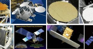
Geosynchronous Space Situational Awareness Program — GSSAP
GSSAP provides enhanced space-based space situational awareness to improve the ability to rapidly detect, warn, characterize and attribute disturbances to space systems in the geosynchronous environment. This assists in the protection of the assets in space that affect many facets of daily life such as navigation and communication. GSSAP supports U.S. Strategic Command’s ability to collect data on man-made orbiting objects.
GSSAP became operational in September 2015, when the first two GSSAP satellites reached their Initial Operational Capability. The two newest satellites to the program, GSSAP 3 and 4, were launched into orbit Aug. 19, 2016, and have now finished their testing phase.
“GSSAP 3 and 4 will significantly enhance our ability to characterize objects on geosynchronous orbit,” said Gen. Jay Raymond, commander of Air Force Space Command. “This provides the awareness we need to successfully operate in space.” This addition to GSSAP is vital to expand 1 SOPS’s space-based space situational awareness mission. It not only provides a significant improvement in space object characterization, but also in detecting threats.
From a near-geosynchronous orbit, it has a clear, unobstructed and distinct vantage point for viewing Resident Space Objects (RSOs) without the interruption of weather or the atmospheric distortion that can limit ground-based systems.
The GSSAP satellite system can characterize objects in space to a very refined level. Being able to discriminate and characterize objects assists the U.S. and its allies in achieving responsible and safe use of space. The information obtained by this program provides robust spaceflight safety information and ensures free access to, and use of, space.
Rendezvous and Proximity Operations (RPO)
GSSAP satellites support Joint Functional Component Command for Space (JFCC SPACE) tasking to collect space situational awareness data allowing for more accurate tracking and characterization of man made orbiting objects.
GSSAP satellites operate near the geosynchronous belt and have the capability to perform Rendezvous and Proximity Operations (RPO). RPO allows for the space vehicle to maneuver near a resident space object of interest, enabling characterization for anomaly resolution and enhanced surveillance, while maintaining flight safety. Data from GSSAP uniquely contributes to timely and accurate orbital predictions, enhancing our knowledge of the geosynchronous orbit environment, and further enabling space flight safety to include satellite collision avoidance.
GSSAP satellites communicate information through the world-wide Air Force Satellite Control Network (AFSCN) ground stations, then to Schriever Air Force Base, CO where 50th Space Wing satellite operators of the 1st Space Operations Squadron (1 SOPS) oversee day-to-day operations.
As space continues to become more congested and contested, GSSAP and other space situational awareness programs are paramount in deterring aggressive action in space. GSSAP continues to enable safe operations and protects U.S. and allied spacecraft by providing timely and accurate situational awareness. Ultimately, GSSAP and 1 SOPS enable a range of decisive responses that will render any counter-space threats ineffective.
Minotaur rocket launches Air Force tracking satellite
Orbital ATK, the Minotaur 4 rocket’s commercial operator, injected the ORS-5 payload into an orbit between 372 and 375 miles (599 to 604 kilometers), very near prelaunch predictions. The ORS-5/SensorSat satellite, built by the Massachusetts Institute of Technology’s Lincoln Laboratory, is equipped with a single instrument, a telescope designed to monitor satellites in geosynchronous orbit 22,300 miles above the equator.
“The capabilities ORS-5 brings to the nation are ushering in a new era of faster, cheaper satellite development,” said Lt. Gen. John Thompson, commander of the Air Force Space and Missile Systems Center. “ORS-5 will deliver global, persistent, optical tracking of satellites in geosynchronous orbit, enabling the nation to have increased global situational awareness of space objects.”
Another way to look at it is to compare the ORS-5 satellite to an airport radar, said Grant Stokes, head of the space systems and technology division of the Massachusetts Institute of Technology’s Lincoln Laboratory, where the spacecraft was developed and manufactured.
“It’s sort of analogous to a surveillance radar at an airport, which goes around and around, surveilling the domain,” Stokes told reporters in a prelaunch briefing Thursday. “Once per orbit, what ORS-5 will do is scan the GEO (geosynchronous) belt and keep track, essentially, of all the items there.
“The GEO belt is particularly important,” Stokes said. “There’s a huge collection of satellites there, and a tremendous amount of economic value in that special orbit, so it is one that generally we want to keep fairly good tabs on what’s there and where things are.”
Satellites in geosynchronous orbit nearly 22,300 miles (35,800 kilometers) above the equator fly around Earth at the same rate the planet rotates. The effect at that altitude keeps satellites over the same geographic position at all times.
Designed for a three-year mission, ORS-5 should feed military officials data on how objects are moving around geosynchronous orbit. After identifying which objects might be threats, the Air Force could task the more capable SBSS Block 10 satellite to take better pictures, or send one of the military’s four close-up inspection satellites in geosynchronous orbit to take a closer look, according to Lt. Col. Heather Bogstie, ORS-5 program manager.
The data output from ORS-5 “gives you dots on a screen,” Stokes said. “We very carefully measure how bright they are, but it does not resolve in any way,” he said. “It’s a dot at a distance of something like 40,000 kilometers (nearly 25,000 miles).”
Punjani said the ORS-5 satellite is a “change detection agent” to collect imagery of broad swaths of space. In keeping with the ORS program’s low-cost ethos, the ORS-5 mission was conceived to meet minimum standards required by the military’s space surveillance division, without the bells and whistles on more expensive spacecraft.
The SBSS Block 10 satellite launched in September 2010 cost more than $800 million, around 10 times more than ORS-5. SBSS Block 10 will exceed its seven-year design life later this year, and a full-up replacement satellite is not expected to launch until at least 2021. ORS-5 will fill the potential gap in tracking coverage.
“When you look at how ORS builds our satellites, we’re going to go small,” Punjani said. “We’re going to go to threshold requirements, and then we’re going to hold to those requirements and not change those requirements throughout the life cycle, in order to ensure we rapidly acquire these programs. This program was done within three years, compared to other satellite programs that have a five-to-ten year life cycle.”
The Air Force said the ORS-5 satellite itself cost around $49 million. Another $27.2 million went toward purchasing the Minotaur 4 launch from Orbital ATK, the rocket’s commercial operator, and ground systems cost $11.3 million.
The military needed a dedicated rocket for the ORS-5 mission because of its unique orbit directly over the equator. That type of orbit required the Air Force and Orbital ATK to base the launch from Cape Canaveral instead of from an already-used Minotaur pad at Wallops Island, Virginia.
Officials looked at several launch options, including building a temporary Minotaur launch pad at Kwajalein Atoll in the Marshall Islands, or at the European-run Guiana Space Center in South America.