Digital battlefields, hybrid warfare, and the future of threat intelligence
IDST Intelligence Briefings
(Latest Security & Cyber Videos)
Why This Magazine Exists
Security, Cyber & Counter-Threats examines the evolving landscape of modern security in an era defined by digital conflict, hybrid warfare, and persistent global threats.
From cyber operations, information warfare, and intelligence-driven defense to counter-terrorism, internal security, and emerging threat vectors, this magazine provides strategic analysis, technical insight, and policy-relevant perspectives for decision-makers, practitioners, and researchers navigating an increasingly contested security environment.
What We Track
- Cyber warfare & cyber defense
- Information operations & influence campaigns
- National security threat assessments
- Emerging digital and hybrid warfare doctrines
- Critical infrastructure & cyber resilience
Latest Analysis & Intelligence
-
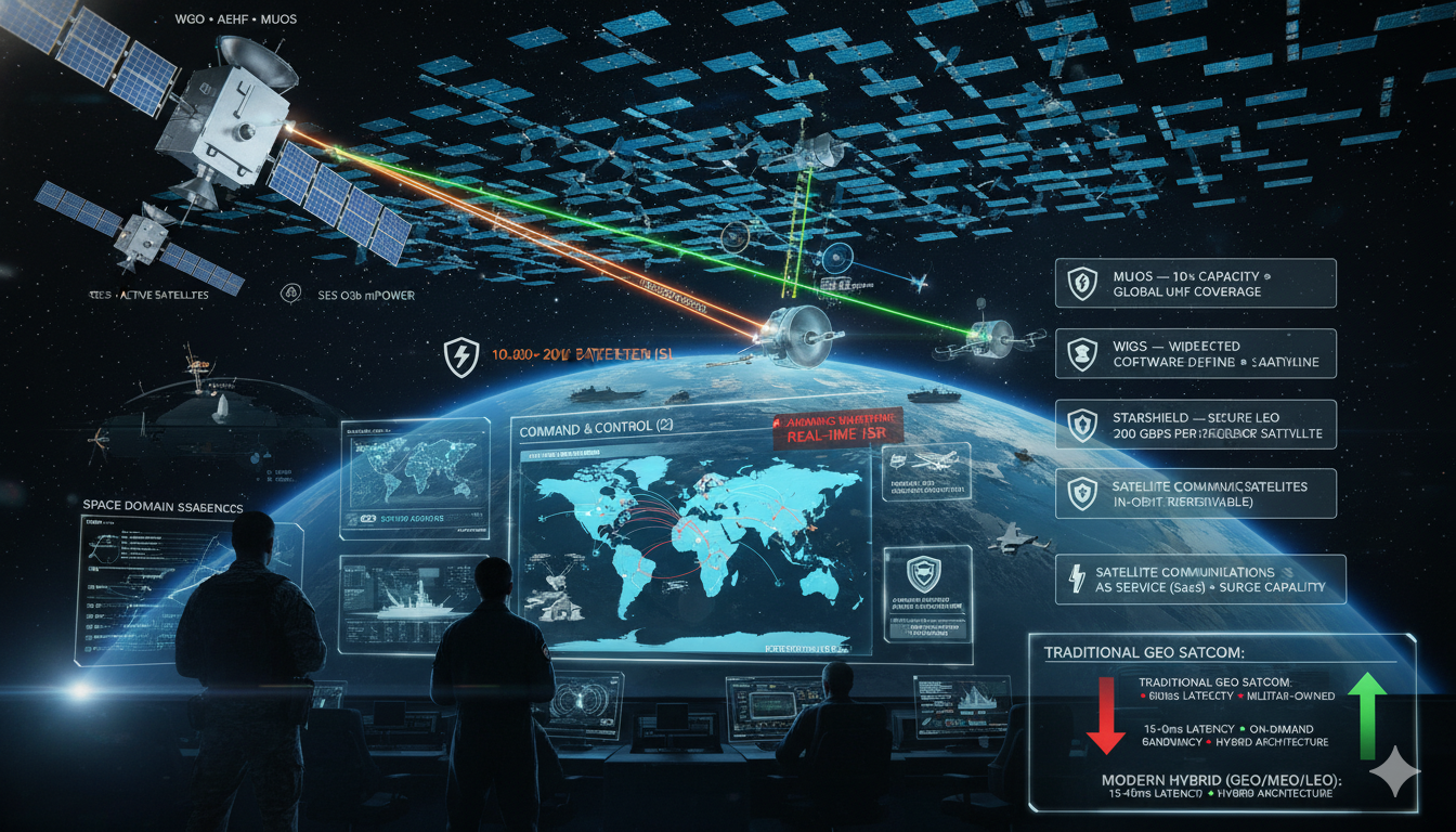
Military Satellite Communication (MILSATCOM): Technology, Trends, and Strategic Imperatives (2026 Update)
Securing the High Ground: How Space-Based Communications Are Reshaping Modern Warfare Executive Summary Military satellite communication (MILSATCOM) has evolved from a supporting enabler into a core warfighting infrastructure layer underpinning modern multi-domain operations. The integration of proliferated Low Earth Orbit (LEO) constellations, software-defined satellites, and hybrid military-commercial architectures has fundamentally transformed global defense communication systems.…
-

Expect the Unexpected: 2026 Strategies to Anticipate and Defeat Cyber Threats
Introduction Cybersecurity in 2026 has entered a new operating era defined by speed, automation, and strategic consequence. Threat actors now combine ransomware-as-a-service ecosystems, AI-enabled phishing, deepfake impersonation, supply-chain compromise, credential theft, and automated reconnaissance to attack organizations faster and at lower cost than ever before. What once required skilled operators and weeks of preparation can…
-

The Future of Remote Sensing: Novel LIDAR Technologies for Diverse Applications
Reframing LiDAR in the Era of Intelligent Sensing LiDAR (Light Detection and Ranging) is no longer just a mapping tool—it is rapidly evolving into a core sensing infrastructure for autonomy, environmental intelligence, and defense awareness. Historically valued for its ability to generate high-resolution 3D point clouds, LiDAR is now undergoing a profound transformation driven by…
-
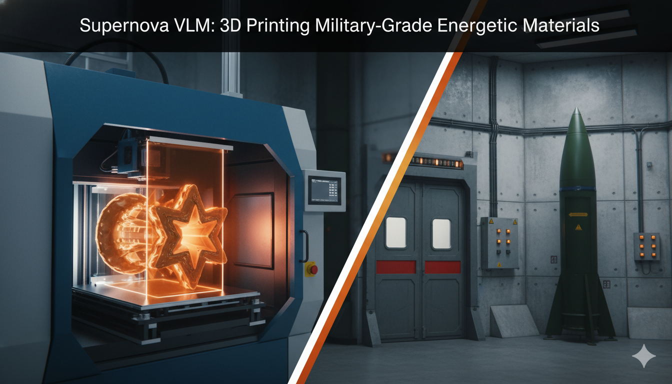
The Explosive Frontier: Additive Manufacturing and the Strategic Transformation of Energetic Materials
Reframing Energetics in the Era of Digital Manufacturing For decades, the production of propellants, explosives, and pyrotechnics has remained one of the least digitized segments of advanced manufacturing—constrained by legacy processes such as casting, pressing, and extrusion that date back to the mid-20th century. These methods impose severe geometric limitations, long production cycles, and significant…
-

Earth Observation Constellations: Planetary Intelligence in Real Time
How Satellite Constellations Are Transforming Disaster Response, Climate Monitoring, and Global Security Through Real-Time Planetary Insights Executive Summary Earth Observation (EO) constellations have transitioned from niche scientific assets into critical global infrastructure underpinning environmental monitoring, economic intelligence, and national security. Enabled by NewSpace economics, reusable launch systems, and advances in sensor miniaturization, constellations of small…
-
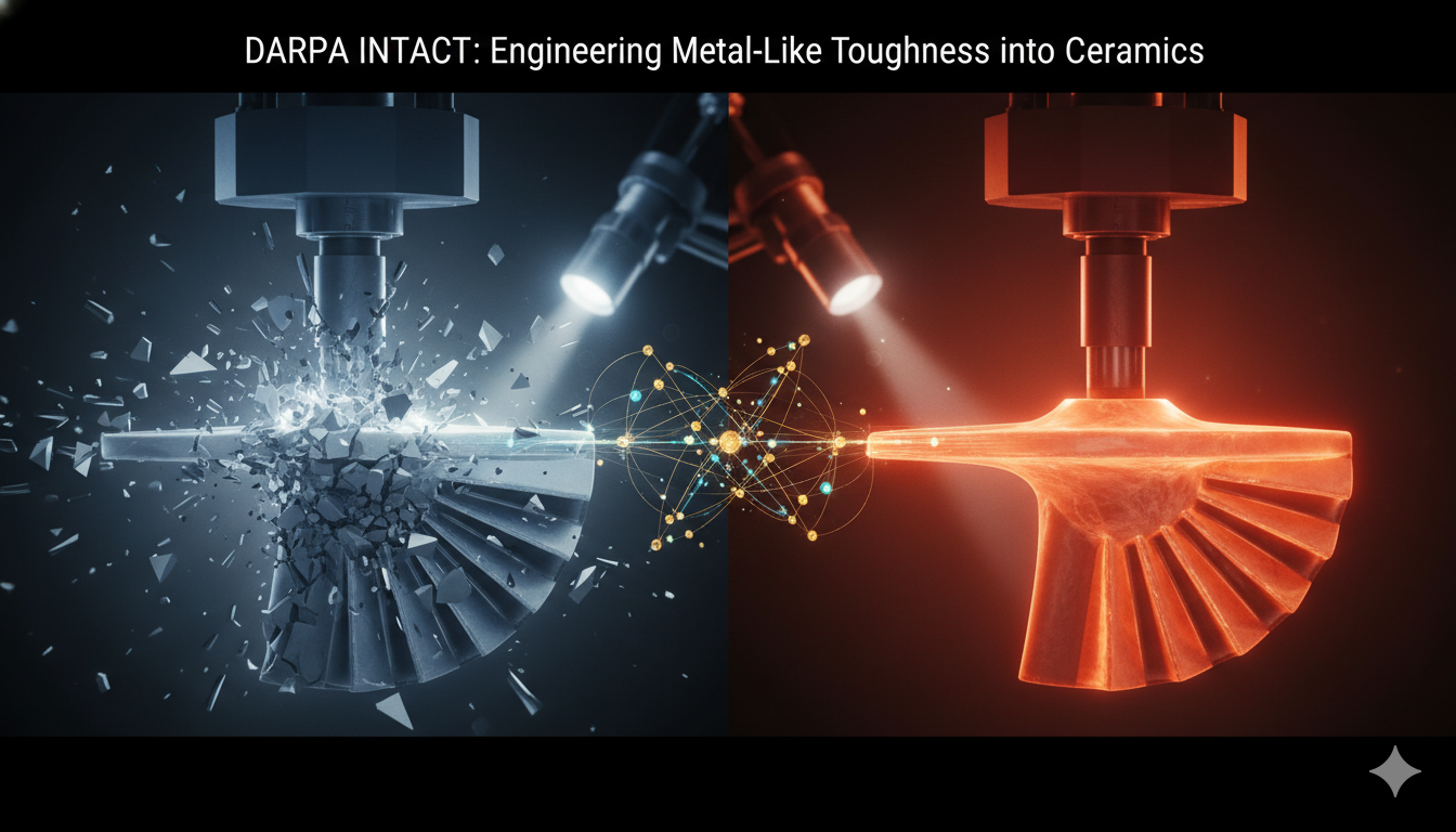
Breaking the Brittle Barrier: DARPA’s INTACT Program and the Strategic Race for Damage-Tolerant Ceramics
Reframing the Materials Challenge For more than half a century, advanced engineering has been constrained by a fundamental trade-off: metals deform but melt, ceramics endure heat but fracture. This dichotomy has shaped everything from turbine design to hypersonic vehicle architecture. While nickel-based superalloys and titanium composites have steadily improved, they are approaching thermodynamic and microstructural…
-

Pushing the Boundaries of Superconductivity: Investigating the Materials and Technologies behind High-Temperature Superconductors
Introduction Since the discovery of superconductivity in 1911, the field has represented one of science’s most compelling promises: the ability to transmit electricity with zero resistance and generate powerful magnetic fields with extraordinary efficiency. For decades, however, superconductivity remained largely confined to laboratory environments because early materials required cooling near absolute zero. The resulting dependence…
STRATEGIC SUB-MAGAZINES
Modern military power emerges from the interaction of platforms, people, doctrine, and integration across domains. The Defense & Military Systems magazine is structured into focused sub-magazines that examine how combat capability is built, sustained, and employed across air, land, sea, weapons, and human systems.
Cyber & Information Warfare
Industrial outcomes are shaped as much by incentives, policy, and market structure as by engineering. Price signals, investment cycles, and regulatory frameworks quietly determine which technologies scale, stagnate, or fail.
This sub-magazine examines how markets behave under strategic pressure—where capital flows, how demand signals distort decisions, and why some industries adapt faster than others.
Explore the Cyber & Information Warfare Sub-Magazine →
Security & Threat Management
Modern security is defined by persistence, coordination, and anticipation. This sub-magazine focuses on how threats are identified, mitigated, and managed across institutions, infrastructures, and societies.
Explore the Security & Threat Management Sub-Magazine →