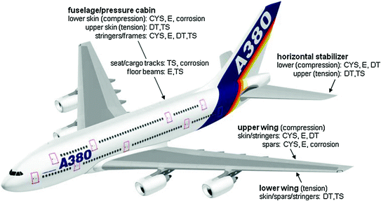
Introduction
The detection of subterranean threats has long been a challenge for military and security forces. Tunnels, underground bunkers, and hidden weapons caches pose significant risks, particularly in conflict zones and border areas. Traditional detection methods, such as ground-penetrating radar and seismic sensors, have limitations in terms of depth penetration and false positives. In response to these challenges, the Defense Advanced Research Projects Agency (DARPA) launched the Gravity Anomaly for Tunnel Exposure (GATE) program in 2009. This innovative initiative leverages gravity gradiometry to identify underground structures with unprecedented precision.
The Science Behind Gravity Anomaly Detection
Gravity gradiometers are highly sensitive instruments that measure minute variations in the Earth’s gravitational field. When a mass is removed—such as in the case of an underground tunnel—the local gravitational pull is slightly altered. These tiny fluctuations can be detected and analyzed to distinguish between natural geological formations and man-made voids.
Unlike traditional gravity sensors, which measure the total gravitational force at a single point, gravity gradiometers detect changes in gravitational pull over a small distance. This ability allows for the identification of underground anomalies without interference from large-scale geological features. By processing these data in real time, airborne sensors can create a detailed map of the subsurface, revealing hidden tunnels, underground bunkers, and other concealed threats.
DARPA’s Vision for GATE
DARPA’s GATE program was designed to develop an airborne system capable of detecting underground threats over vast areas. The primary objective was to build a lightweight, high-resolution gravity gradiometer that could be mounted on low-flying aircraft or unmanned aerial vehicles (UAVs).
By deploying gravity gradiometry in an airborne platform, the military could potentially map underground networks on a large scale, reducing reliance on localized ground-based detection methods. The GATE program aimed to enhance national security by enabling rapid, non-invasive detection of tunnels used for smuggling, insurgent movement, and potential nuclear stockpile concealment.
Lockheed Martin’s Role in the GATE Program
In 2009, Lockheed Martin was awarded a $4.8 million contract to develop a prototype gravity sensor for DARPA’s GATE program. The sensor was designed to operate from low-altitude aircraft or UAVs, scanning the ground below for anomalies in gravitational pull.
According to Dr. James Archibald from Lockheed Martin, this technology has significant implications for border security, military operations, and counterterrorism efforts. By identifying subterranean threats before they become operational, the military could prevent underground infiltration, smuggling, and surprise attacks.
Challenges and Limitations of Airborne Gravity Gradiometry
While the GATE program presents a revolutionary approach to underground detection, several technical and operational challenges must be addressed before widespread deployment. One of the primary challenges is the precision and sensitivity required for detecting underground structures. Gravity anomalies caused by tunnels or bunkers are often very small, necessitating the use of extremely precise instrumentation. While modern gravity gradiometers have improved sensitivity, detecting shallow and small tunnels remains difficult.
Environmental interference poses another significant challenge. Factors such as local terrain, atmospheric conditions, and background noise can affect the accuracy of gravity measurements. These must be accounted for in data analysis to avoid false positives. Moreover, the effectiveness of airborne gravity gradiometry depends on low-altitude flight operations, which may not always be feasible in military settings. Most Air Force operations involve high-altitude flights, making integration of this technology into standard military procedures more complex.
Operational speed and coverage are also concerns. While gravity sensing provides deep penetration into the Earth, scanning large areas efficiently requires optimized flight paths and advanced data processing capabilities. The ability to process and analyze data in real time is crucial to ensure that threats are identified quickly and accurately.
Applications Beyond Military Use
Although initially developed for defense and security applications, gravity gradiometry has a wide range of civilian applications. Historically, it has been used in oil and gas exploration to detect underground reservoirs, in geological surveys to map underground rock formations and faults, and in infrastructure monitoring to identify subsurface voids or sinkholes that could endanger buildings or roads.
The application of gravity gradiometry to national security marks a significant shift, demonstrating the potential for dual-use technology that benefits both military and civilian sectors. If further refined, this technology could play a critical role in disaster preparedness, such as detecting underground collapses after earthquakes or monitoring changes in underground water reservoirs.
Future of Underground Threat Detection
The GATE program represents a pioneering step in the use of gravity-based sensing for underground detection. As quantum gravity sensing technology advances, we can expect even more sensitive and miniaturized sensors that will make gravity anomaly detection faster, more precise, and easier to deploy.
The integration of AI and machine learning with gravity sensing could further enhance anomaly detection accuracy, distinguishing between man-made structures and natural formations with greater confidence. Future versions of this technology could be mounted on high-altitude drones, satellites, or even ground-based robotic systems, expanding the scope of underground surveillance worldwide.
Conclusion
DARPA’s GATE program is an ambitious attempt to revolutionize underground threat detection using gravity anomaly sensing. By developing advanced gravity gradiometers, the program aims to provide a non-invasive, large-scale method for identifying tunnels, bunkers, and hidden threats. Although technical challenges remain, the potential benefits in military, border security, and counterterrorism operations make this an area of ongoing research and development.
As quantum technology progresses, the ability to map the subterranean world with unprecedented precision will become a reality, making underground threats far less invisible than they are today.