The Global Positioning System (GPS), is a global navigation satellite system (GNSS) that provides location and time information in all weather conditions, anywhere on or near the Earth where there is an unobstructed line of sight to four or more GPS satellites. Each one transmits information about its position and the current time at regular intervals. These signals, traveling at the speed of light, are intercepted by your GPS receiver. GPS receivers then calculate the distance of each satellite based on how long it took for the messages to arrive. It requires only three satellites to provide the location. The other satellites add to the accuracy. The more satellites there are in the sky, the more accurately GPS can tell you about your location.
GPS has become ubiquitous technology that provides real-time positioning, navigation and timing (PNT) data in cars, boats, planes, trains, smartphones and wristwatches, and has enabled advances as wide-ranging as driverless cars, precision munitions, and automated supply chain management.
However, Global Positioning System is controlled by USA Govt. If they want, they can switch off this GPS without any explanation. This happened during the Kargil war in 1999, when Pakistani troops took the position in high mountains, and one of the first things Indian military was trying to get their hands on was GPS data of the region. GPS could’ve provided vital information, but the United States denied access to India. This can be considered as an act of Information warfare.
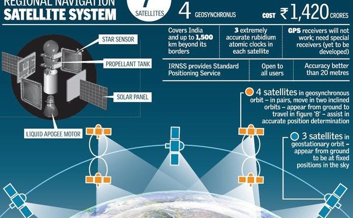
The Indian Government launched development of Indian Regional Navigation Satellite System (IRNSS) in 2006, with aim to develop an autonomous regional satellite navigation which would be under complete control of the Indian government. American monopoly on satellite based navigation is all set to end now as ISRO has developed the Indian Regional Navigation Satellite System (IRNSS), an independent and indigenous regional spaceborne navigation system for national applications.
The Indian Regional Navigation Satellite System (IRNSS), with an operational name of NavIC (acronym for Navigation with Indian Constellation; also, nāvik ‘sailor’ or ‘navigator’ in Indian languages), is an autonomous regional satellite navigation system that provides accurate real-time positioning and timing services. It is designed to provide accurate position information service to users in India as well as the region extending up to 1500 km from its boundary, which is its primary service area. An Extended Service Area lies between primary service area and area enclosed by the rectangle from Latitude 30 deg South to 50 deg North, Longitude 30 deg East to 130 deg East.
ISRO indicates that eventually NavIC applications will support: Terrestrial, aerial and marine navigation, Disaster management, Vehicle tracking and fleet management, Integration with mobile phones, Precise timing, Mapping and geodetic data capture, Terrestrial navigation aid for hikers and travellers, Visual and voice navigation for drivers. In addition, India have combined NavIC capability with its satellite-based air traffic control system for civil aviation called GAGAN (GPS Aided Geo Augmented Navigation). Hardware companies are producing GPS receiver modules specifically for the emerging Indian market that are compatible with GPS and GAGAN.
Further, the IRNSS is recognised by the International Maritime Organisation (IMO) as a part of the World Wide Radio Navigation System (WWRNS). “The Maritime Safety Committee of IMO during its recent meeting held from 4 to 11 November 2020 has approved the recognition of the IRNSS as a component of the World-wide radio navigation system,” the statement said. This achievement is considered as a significant step towards the ‘Atmanirbhar Bharat’ initiative of the Union government.
The main goal behind designing the Indian Regional Navigation Satellite System (IRNSS) is to provide accurate position information services to assist in the navigation of ships in Indian Ocean waters. For getting the recognition, the Director General of Shipping (DGS) had approached the IMO for granting recognition to the IRNSS as a component of the WWRNS. Apart from India, the other three countries who already have their own navigation systems recognised by the IMO includes the US, Russia and China.
While talking about the IRNSS, Kumar said that it is a modern and more accurate navigation system and over 2,500 merchant vessels in Indian waters at any given time will now be able to use the system. Further, the IRNSS will be utilized to assist in the navigation of ships in ocean waters within the area of approximately 1,500 km from the Indian boundary, according to Kumar. Details of the tests carried out on merchant ships with regard to the accuracy of the system were included in the report prepared by Indian Space Research Organisation (ISRO) which was submitted to IMO for consideration,” as per his statement.
The additional precision and resilience increase the scope of projects that can support India’s economic development. They include supporting the Archaeological Survey of India in protecting India’s heritage sites, assisting the fishing industry to locate the best fishing areas, development of transportation networks (especially bridges, flyovers and elevated expressways), help in defining accurate land records, and supporting the Indian railways to reduce accidents at automated railway crossings in addition to improving real-time railway operations. IRNSS shall also be very vital for military by providing intelligence about Enemy units and weapons in battlefield, and providing guidance to precision munitions.
As per National Defense Authorization Act (NDAA) 2020, United States Secretary of Defense in consultation with Director of National Intelligence will designate NavIC, Galileo and QZSS as allied navigational satellite system.