Lidars (Light Detection and Ranging) are similar to radars in that they operate by sending light pulses to the targets and calculate distances by measuring the received time. The key advantages of LIDAR is its superior accuracy and its ability to see through masking items, such as leaves, trees, and even camouflaged netting.
LIDAR systems have high accuracy due to its high spatial resolution due to the small focus diameter of the beam, as well as a higher pulse repetition rate. Since they use light pulses that have about 100,000 times smaller wavelength than radio waves used by radar, they have much higher resolution. That makes lidar better at detecting smaller objects and at figuring out whether an object on the side of the road is a pedestrian, a motorcycle, or a stray pile of garbage.
LIDARs are rapidly gaining maturity as very capable sensors for number of applications such as imaging through clouds, vegetation and camouflage, 3D mapping and terrain visualization, meteorology, navigation and obstacle avoidance for robotics as well as weapon guidance. LIDAR data is both high-resolution and high-accuracy, enabling improved battlefield visualization, mission planning and force protection. LIDAR provides a way to see urban areas in rich 3-D views that give tactical forces unprecedented awareness in urban environments.
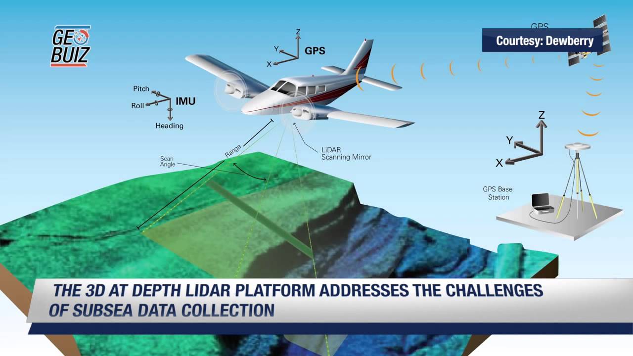
Airborne LIDARs can calculate accurate three dimensional coordinates of both manmade and naturally occurring targets by combining the laser range, laser scan angle, laser position from GPS, and laser orientation from Inertial Navigation System. Additional information about the object, like its velocity or material composition, can also be determined by measuring certain properties of the reflected signal, such as the induced Doppler shift.
The military uses 3D data capture for a number of applications. The detailed mapping of urban and non-urban terrain can greatly benefit military operations, both from the air and semi-autonomous vehicles. The military depends on LiDAR technology to map out the exact terrain of the battlefield and know the exact position of the enemy and their capacity. The technology can also be used to locate all enemy weaponry including tankers and help in neutralizing the threat on a much larger scale. Among other things, it can be used for air defence, air traffic control, ground surveillance, navigation, search and rescue, fire control radars, and identification of moving targets.
Swedish Defence Research Agency (FOI) have been working on demonstrating the possibilities for airborne sensor systems, especially 3D imaging ladar on different multi-rotor UAVs for research and development purposes. With UAVs we can cover larger survey areas, and detect other objects or regions of interest (e.g., those that are obscured by high levels of vegetation), than we can with systems based on ground vehicles.
They have also proved useful for disaster management missions; emergency relief workers could use LIDAR to gauge the damage to remote areas after a storm or other cataclysmic event. After the January 2010 Haiti earthquake; a single pass by a business jet flying at 10,000 feet over Port-au-Prince was able to display the precise height of rubble strewn in city streets enabled by 30 centimeters resolution LIDAR.
Russia’s state-owned TASS media reported that Zala, a Russian company under the broader umbrella of the Kalashnikov defense complex, is putting LIDAR on its drones for the first time. These light detection and ranging systems are commonly used to create 3-D models of the world, and LIDAR is an important part of most autonomous vehicle designs. The announcement at TASS notes that LIDAR on Zala drones will allow for better inspections of infrastructure and terrain, in ways that existing ground-based or manned aircraft technologies cannot provide.