The rapid pace of new commercial satellite constellation launches has led to a corresponding increase in the amount and availability of geospatial data. While these constellations largely focus on non-military uses, their data has numerous military applications. For example, the new constellations provide optical, synthetic aperture radar (SAR), and Radio Frequency (RF) data that could provide situational awareness, event detection, monitoring, and tracking capabilities. Unlike traditional geospatial data collection approaches, these constellations provide global coverage at high revisit rates without requiring specific tasking.
Further, non-satellite geospatial data is also now widespread, including crowdsourced information such as OpenStreetMap, which provides insight on places and objects. There is currently no comprehensive repository or straightforward way to access and exploit this multimodal data.
Unfortunately, no straightforward way currently exists for analysts to access and analyze all of that imagery. The current ad hoc, time-intensive approach requires gathering and curating data from a large number of available sources, downloading it to specific locations, and running it through separate suites of analytics tools.
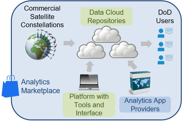
To help overcome these challenges, DARPA’s new Geospatial Cloud Analytics (GCA) program seeks to enable instant access to the most up-to-date images anywhere in the world, as well as cutting-edge tools to analyze them. It would achieve this capability by virtually aggregating vast amounts of commercial and open-source satellite data that is available in multiple modes—optical, synthetic aperture radar (SAR), and radio frequency (RF)—in a common cloud-based repository with automated curation tools. The platform and tools would provide DoD geospatial analysts global situational awareness, event detection, monitoring, and tracking capabilities beneficial to U.S. forces around the world.
In addition to developing a scalable geospatial data platform with tools and a user interface, GCA aims to create analytical applications that would allow analysts at the operational and tactical level to draw specific information from the aggregated data. GCA will pilot an analytical services business model where commercial entities offer analytics services and apps via a competitive marketplace.
“The goal of GCA is to provide a secure cloud-based platform that automatically curates multi-source global data and metadata, allowing analysts to focus their attention and expertise on analysis—not data collection, aggregation, and curation,” said Joe Evans, program manager in DARPA’s Strategic Technology Office (STO). “The vision is for commercial analytics providers to use the common data platform to develop and offer their services in an analytics marketplace. This marketplace framework would allow the DoD to more cost-effectively leverage constantly refreshed, robust commercial analytics services.”
To test the utility of the cloud-based platform and apps in the analytics marketplace, the GCA program will look at problems at a variety of time scales. These include predicting food shortages in a region of the world (weeks to months), locating the construction of oil fracking sites (days to weeks), illegal fishing detection (minutes to days), and an open-call scenario where proposers may suggest other problems of military relevance.