The Internet of Things (IoT) is a system of interrelated computing devices, mechanical and digital machines, objects, animals or people that are provided with unique identifiers (UIDs) and the ability to transfer data over a network without requiring human-to-human or human-to-computer interaction. By 2025, it is predicted that there can be as many as 100 billion connected IoT devices or network of everyday objects as well as sensors that will be infused with intelligence and computing capability.
The growing Internet of Things is mostly a land-based phenomenon, frequently in large cities with loads of sensors. It is heavily influenced by the future prospects of warfare in an urban environment and involves the use of sensors, munitions, vehicles, robots, human-wearable biometrics, and other smart technology that is relevant on the battlefield
But researchers at the Defense Advanced Research Projects Agency (DARPA) foresee a wide range of military and civil benefits from extending the Internet of Things out to sea. While satellites can provide some information, DARPA project manager John Waterson points out that there are gaps in their coverage – optical satellites cannot see through clouds, radar satellites only have limited coverage, and none of them can say much about what is going on underwater. DARPA launched OoT program which can be considered as one of the aplications of the Internet of Military Things (IoMT) in the maritime and underwater domain for the purposes of reconnaissance, surveillance, and other combat-related objectives.“Oceans cover more than 70 percent of the earth’s surface, but we know very little about them,” said Ersin Uzun, vice president and general manager of the Internet of Things team at Xerox.
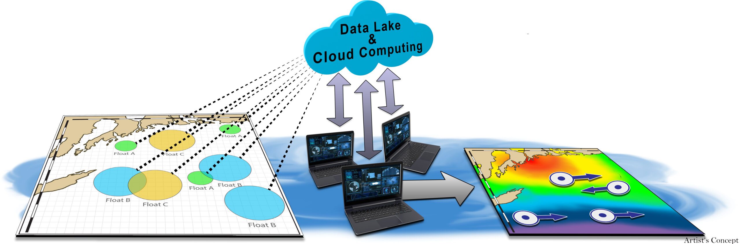
Existing naval and commercial platforms are constrained to localized situational awareness from their organic sensors, and support by remote sensors is often restricted by the physical environment (e.g., fog, rain, cloud cover). Ocean of Things will address these gaps in ocean understanding to benefit all users of maritime data.The Ocean of Things program will provide persistent, wide-area sensor coverage across the maritime environment through the employment of thousands of intelligent floating platforms, the agency said. Along with machine learning and multi-sensor fusion techniques, the Ocean of Things would detect object and sensor motion used to track vessels, aircraft and even marine mammals.
The similar concept proved highly successful during the Cold War, when the U.S. Navy laid fixed networks of underwater hydrophones on the ocean floor called the “Sound Surveillance System” (SOSUS) to detect Soviet submarines transiting from their bases to patrol areas in the Atlantic and Pacific Oceans. Listening arrays placed in strategic chokepoints that those submarines would necessarily have to transit, like the waters between Greenland, Iceland, and Scotland — the so-called “GIUK Gap” — notionally let the United States know every time a Soviet submarine entered the North Atlantic, allowing the U.S. Navy to direct its own ships or submarines to track them. But since then submarines have become much stealthier and require advanced analytics and machine learning to detect them.
Floating sensors, known as floats, can gather far more detailed information, and can remain at sea for months at a time. There is a network of almost 4,000 Argo science floats around the world, gathering data on ocean temperature and salinity, that uses several thousand battery-powered, robotic floating devices to measure temperature, salinity and current for climate and oceanographic research. The floats mostly drift 10 days at a time below the ocean surface. After rising and transmitting their data to satellites, they return to depth to drift for another 10 days. The floats go as deep as 2,000 meters, according to the Argo website.
However, the Internet of Underwater Things (IoUT), is much larger world-wide network of smart interconnected underwater objects that would transmit data from existing and planned roaming, autonomous vehicles and underwater sensor networks to networks above surface in real time. Waterson wants to see much larger arrays of low-cost floats with more sensors, floats which would carry out missions lasting up to a year before scuttling themselves and degrading. The floats are environmentally friendly, avoiding the use of toxic materials. The Defense Advanced Research Agency’s “Ocean of Things” initiative would then transmit data collected by commercial sensors and crunched by new analytics tools via satellite to a cloud network. There it would be stored and prepped for real-time analysis, program officials said.
“The persistent coverage provided by dispersed sensors provides round-the-clock coverage that other sources of data like an MPA [maritime patrol aircraft] or a SAR [synthetic aperture radar] satellite, which cover a given area for a certain amount of time before moving on, cannot,” says Dr. Sidharth Kaushal, an expert on sea power at the U.K. defense think tank RUSI. Kaushal notes that as well as directly observing vessels and aircraft, the OoT will be able to measure variables like temperature, ocean salinity and ambient underwater noise, which are important for calibrating sonar during anti-submarine operations. The OoT will not be limited to any specific role; the variety of sensors, coupled with powerful data-processing techniques, mean it might be reconfigured to deal with emerging threats. For example, OoT might form a defensive picket to detect, track and locate incoming Russian Poseidon nuclear torpedoes so they could be intercepted. “This fits into a wider concept of Mosaic Warfare creating a system the components of which can reform and interact in multiple ways rather than relying on a hierarchical system,” says Kaushal.
DARPA is partnering with the National Oceanic and Atmospheric Administration, the National Weather Service, the University of Southern Mississippi, the University of Miami, multiple private companies and other entities. Waterston notes that he has brochures from Chinese and Spanish companies working on similar systems.
According to Waterston: “It’s so immense, covering 70% of the Earth’s surface, yet even with all of the ships, all of the aircraft, all of the satellites, and all of the existing sensors, we are severely undersampling this environment.”
China is also planning to build a massive underwater observation system across the disputed East and South China seas, that experts say could be used to detect the movement of foreign ships and diminish the stealth capabilities of US submarines. However China’s Blue Ocean sensors are tethered in place and appear to be mainly for radar and optical observation; there are believed to be hydrophone arrays on the sea bed. By contrast the OoT is much smaller and expendable, and could be deployed anywhere that the U.S. requires detailed, persistent observation of maritime activity, thousands of floating eyes to see over, on and under the sea.