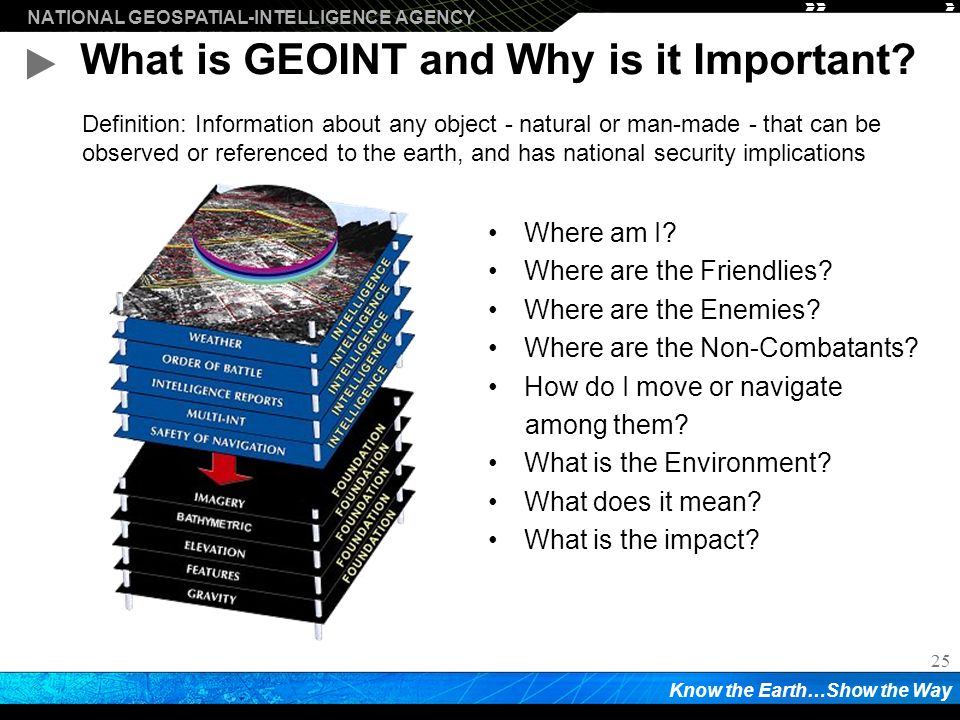
Geoint is imagery and information that relates human activity to geography. It typically is collected from satellites and aircraft and can illuminate patterns not easily detectable by other means. GEOINT (GEOspatial INTelligence) is the foundation of intelligence, it is the process with which skilled analysts evaluate and correlate information, either newly collected or archived, that turns this information into usable and relevant intelligence. In the civilian world, it is more commonly known as remote sensing.
Geospatial intelligence (GEOINT) is intelligence about human activity on earth derived from the exploitation and analysis of imagery and geospatial information that describes, assesses, and visually depicts physical features and geographically referenced activities on the Earth. GEOINT, as defined in US Code, consists of imagery, imagery intelligence (IMINT) and geospatial information. Geospatial intelligence (GEOINT) is a broad field that encompasses the intersection of geospatial data with social, political, environmental, and numerous other factors.
Traditional Geospatial-Intelligence data sources include imagery and mapping data, whether collected by commercial satellite, government satellite, aircraft (such as Unmanned Aerial Vehicles [UAV] or reconnaissance aircraft), or by other means, such as maps and commercial databases, census information, GPS waypoints, utility schematics, or any discrete data that have locations on earth. Traditional Geographic Information Systems (GIS) build and maintain geographic infrastructure. Buildings, roads, poles, rivers, city boundaries, wells, and field boundaries are examples of this. They are fairly fixed in a specific location with associated attributes that can change.
With moving objects, location and time are important to track the object along with any other relevant attributes (temperature, angle, size, color, etc.). Further, Robert Cardillo, the current director of the United States National Geospatial Agency (NGA), advocates that GEOINT should focus on “activity that surrounds an object” rather than the physical item itself. Geospatial Intelligence goes beyond telling that something is happening, where it is happening and when it is happening. It also reveals how it is happening, why it matters and also seek to predict what has or will follow.
GEOINT for Disaster response
With natural disasters becoming an increasing threat in the United States, geospatial intelligence has proved to be invaluable in disaster response. Humanitarian organizations use GEOINT for mitigating damage caused by a range of events and factors, as well as for effectively sending aid to populations facing crises. For example, hurricane evacuation routes are crucial to determining how best to keep civilians safe in the event of a natural disaster.
In COVID-19 vaccination efforts, leveraging spatial information proved valuable in planning, distribution, and post-vaccination tracking. GIS tools like Esri’s CovidPulse Dashboard and the Johns Hopkins University tracking dashboard have helped with monitoring the spread of the virus. Other tools were used to distribute tests, like at Mayo Clinic’s Jacksonville, Florida campus, where autonomous vehicles delivered COVID-19 tests and medical supplies.
Nov 2020 report fom UN Economic and Social Commission for Asia and the Pacific (ESCAP), Geospatial Practices for Sustainable Development, showcased examples from the region’s countries employing applications of space technology to advance sustainable development. “Night-light” satellite images monitoring the impact of lockdowns, “heatmaps” to chart out communities vulnerable to the pandemic and its socio-economic consequences, real-time situational analysis, and dashboards integrating a wide gamut of critical information to support decisions are some of the practices cited.
In addition, combining spatial data from contact tracing, quarantining, and social distancing with digital solutions and artificial intelligence (AI)-driven risk analytics can help enhance community resilience. Such applications can also help in the recovery phase to build back better, by providing an evidence base for decisions on the easing of lockdown and the resumption of economic and social activities, the report added. “The effective integration of geospatial data, with existing statistics and ground-based information, will be key to delivering the timely data needed for governments, businesses, communities and citizens to make evidenced-based decisions”, said Armida Salsiah Alisjahjabana, Executive Secretary of ESCAP.
GEOINT for national security
The growth of national security threats has triggered agencies to further enhance their intelligence and develop a common operating picture to overcome challenges for defense, disaster management, intelligence and maritime and border security.
GEOINT provides many advantages for the warfighter, national security policymakers, homeland security personnel, and intelligence community (IC) collaborators by precisely locating activities and objects; enabling safe navigation over air, land, and sea; assessing and discerning the meaning of events; and providing context for decision-makers. U.S. Department of Homeland Security and the U.S. military rely heavily on geospatial intelligence to protect civilians and better understand the complex issues facing our country, from military threats to natural disasters.
The rapidly evolving state of warfare and the speed of military operations necessitates increasingly accurate intelligence to be collected and delivered instantly, and under very challenging conditions, to units on the ground. This is especially true for Near-peer adversaries that can deploy sophisticated capabilities and pose a serious threat to U.S. and coalition units.
Geospatial intelligence has been an indispensable tool in military operations by providing critical information to commanders to carry out their missions effectively and optimally. Establishing accurate and timely situational awareness is absolutely critical during mission execution.
Accurate, up-to-date GEOINT can create a dynamic digital representation of the battlespace and related real-time situational awareness, which can help establish a decision advantage over our adversaries. This can be achieved by creating a dynamic common operating picture (COP) that brings all of the available intelligence about an AOI into a single 2D or 3D display.
Geospatial Intelligence has an increasing role in Defense and Intelligence as an integrating platform for all military and intelligence information (ISR, planning, situational awareness, and support to deployed forces). Geospatial intelligence has enabled the United States to attribute chemical attacks in Syria to the Assad regime, to predicting strikes by Iraqi insurgents to helping to locate Osama Bin Laden.
For Border and Maritime Security operations, it enhances greater capability in ISR, mission planning and operations across the maritime and littoral environments. National Law Enforcement agencies employ Geospatial technology in national policing operations and international intelligence sharing.
The dual-use of GEOINT has prompted Trump administration to clamp down on the export of AI based Geospatial Intelligence to China which has been spending huge amounts on advanced surveillance technologies or invests more in AI startups and growth businesses. The new regulations target the use of artificial intelligence in geospatial applications—essentially the detection and classification of objects from planes, drones and satellites. While many such applications are civilian in nature—geographical surveys, construction, town planning, the real focus is military and surveillance. Essentially, the U.S. does not want these technologies in enemy hands. The restrictions cover U.S. exports to all countries bar Canada, but the primary target is of course China and its world-leading AI surveillance industry.