 International Defense Security & Technology Your trusted Source for News, Research and Analysis
Related Articles
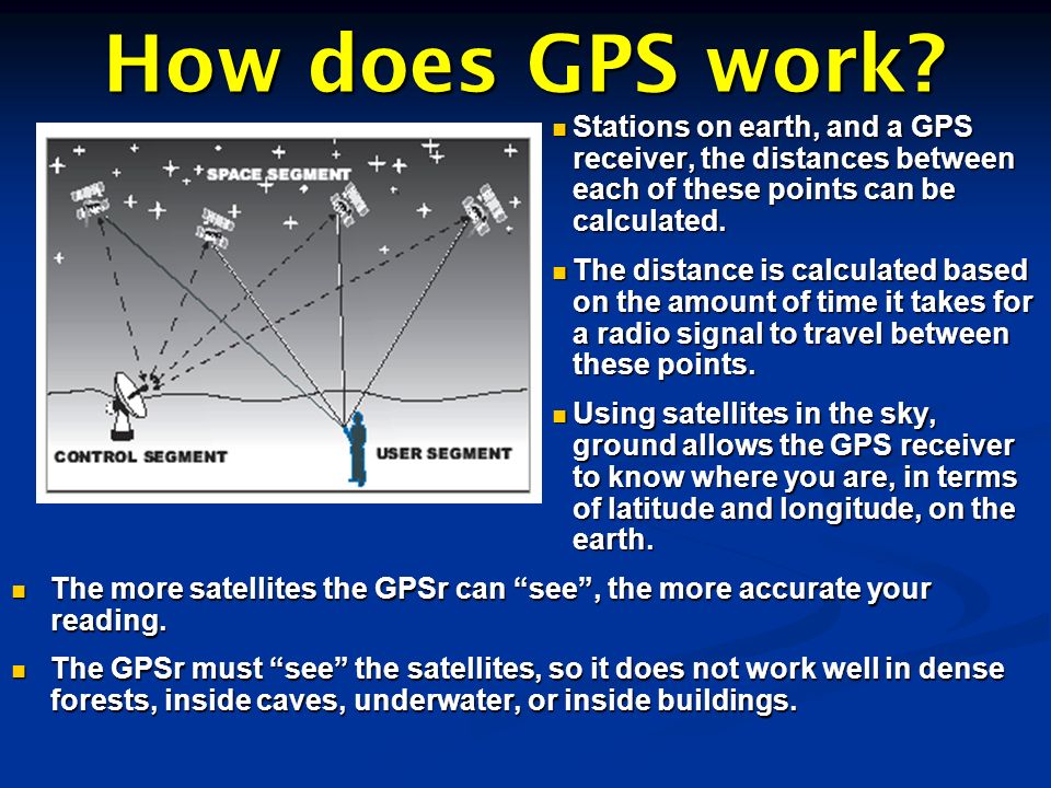
Systems like GPS, Russia’s GLONASS, China’s BeiDou, and Europe’s Galileo systems are Global Satellite Navigation Systems (GNSS) that provides real-time positioning, navigation and timing (PNT) data. The worldwide Global Positioning System (GPS), created in the late 1980s, has evolved to become an essential part of life for nearly every person on the planet.
The 24 satellites that make up the GPS constellation freely provide positioning, timing, and navigational information worldwide–especially for the U.S. military. GPS allows units in the air, on land, and at sea to know their position at all times; quickly agree on a common, synchronized time; and navigate across unfamiliar terrain with relative ease. The system provides critical navigation capabilities to military systems including UAVs, soldiers in the dark or in unfamiliar territory, missile and projectile guidance, target tracking, precision munitions, search and rescue, and to coordinate troop and supply movement. The Joint Direct Attack Munition (JDAM) and other weapons use GPS to achieve unparalleled accuracy. These weapons are capable of traveling for miles and landing within 10 feet of their targets.
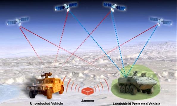
However, in many environments in which military operates (inside buildings, in urban canyons, under dense foliage, underwater, and underground) have limited or no GPS access. Similarly, GPS signals can be significantly degraded or unavailable during solar storms.GPS and GNSS signals are easily disrupted by unintentional interference from radio transmitters. GPS and GNSS signals are extremely weak, cannot penetrate buildings and can easily be jammed. Civilian GPS and GNSS signals are not encrypted and can easily be spoofed
GPS is also vulnerable to jamming attacks, GNSS jammers are now being used by criminals or vehicle hijackers, as reported by the FBI: “… GPS tracking devices have been jammed by criminals engaged in nefarious activity including cargo theft and illicit shipping of goods.Typical military jammers are able to affect GPS receiver for many tens of kilometers by line of sight. It’s a problem because best accuracy, availability and global coverage of PNT data is through GPS/GNSS.
The Pentagon’s reliance on GPS has made its disruption or destruction the number one priority by adversaries in wartime. Anti-satellite weapons, GPS jammers, and even GPS spoofers are designed to destroy, deny, or degrade the network, forcing U.S. and allied forces to rely on older, less accurate ways of determining their finding their way around. Russia, China, and North Korea have all developed and deployed GPS countermeasures, some of which have interfered with civilian GPS usage. In 2019, pilots discovered Russian GPS jamming (to protect Moscow’s forces in Syria) interfering with civilian air traffic in the Eastern Mediterranean, from Cyprus to Israel.
Resilient positioning, navigation and timing (RPNT) is the convergence of positioning, navigation and timing technology with non-traditional and emerging technology to improve the reliability, performance and safety of mission-critical applications in the air, on land and in the sea. Resilient PNT solutions are used where even the smallest discrepancy in data accuracy, availability and stability can result in a mission failure, loss of life, or battlefield disadvantages, and significant economic loss. For example, knowing where your weapon system is located and where the target is located are two of the five critical requirements for accurate predicted indirect fires. Additionally, many indirect fire Precision Guided Munitions (PGMs) use GPS to deliver lethality exactly where it is required to quickly defeat enemy targets with minimal collateral damage, even when the enemy target is very far away.
Militaries are taking multiple approaches Resilient PNT solutions. American U-2 spy plane pilots are wearing watches that connect to foreign Russian, Chinese, and European satellites to obtain navigation coordinates, giving them backup navigation when GPS is jammed. “My U-2 guys fly with a watch now that ties into GPS, but also BeiDou and the Russian [GLONASS] system and the European [Galileo] system so that if somebody jams GPS, they still get the others,” Gen. James “Mike” Holmes, head of Air Combat Command, said Wednesday at a McAleese and Associates conference in Washington. The general mentioned the watch as an example of building redundancies into military equipment.
“Designed with pilots of varying backgrounds and missions, the D2 Charlie aviator watch features a colorful, dynamic moving map which depicts airports, navaids, roads, bodies of water, cities and more, offering greater situational awareness,” the watchmaker said in a statement at the time. “When the D2 Charlie is paired with Garmin Connect on a connected mobile device, pilots can view weather radar on top of the map display relative to flight plan information.”
The Air Force Special Operations Command [AFSOC] requires an interim upgraded system to improve GPS performance in a GPS degraded/denied threat environment. This GPS Hardening Anti-Jamming solution is intended to mitigate and offset these threats until the mandated M-Code solution becomes available.“For the interim solution, the US government is pursuing the acquisition of two digital GPS hardening technologies to replace the existing GAS-1 antenna electronics with digital nulling (the ability of the antenna to remove threat signals from GPS interference) and digital beam steering (the ability to improve extra gain toward GPS satellite). Integrating these improved GPS nulling and beam steering capabilities onboard the MC/EC-130J aircraft will require procuring the Digital Antenna Electronics (DAE) equipment, upgrading the GPS receiver and making the software updates or upgrades to the Dash (-) 5 Embedded GPS/Inertial Navigation System (EGI) without incurring research and development costs.
Another approach is integration of GPS with complementary technologies such as chip-scale atomic clocks and small inertial measurement units of the Microelectromechanical Systems (MEMS).
Third approach is developing entirely new PNT technologies. For example, Rafael’s “Iron Flame” – an autonomous precision artillery rocket system- relies on a guidance capability based on image comparison. This makes it immune to GPS jamming as well enable them to execute a very accurate strike with minimum collateral damage even in urban scenarios, using aerial reconnaissance photographs as a reference image.
Honeywell, for its part, is “working on numerous alternatives to GNSS aiding, including vision aiding, collaborative aiding, celestial aiding, terrain-aided navigation, and using signals of opportunity,” Lund says. “All of this is aimed at allowing our customers to continue to operate without any degradation in performance – even if GNSS signals aren’t available.”
Next generation position, navigation, and timing (PNT) technology that will be less vulnerable to cyber attack is scheduled to reach operational assessment early next year, according to Maj. Gen. Wilson Shoffner, Director of Operations at the Army Rapid Capabilities Office (RCO), speaking at the 16th Annual AFCEA Army IT Day, hosted by the Northern Virginia chapter of the Armed Forces Communications and Electronics Association (AFCEA).
Threat of Navigation Warfare
Deliberate intention jamming is increasingly becoming routine operation that is being increasingly used against adversaries for disruption and deception and in coordination with other kinetic capabilities during conflicts. Russia in Ukraine and recently in Syria, has demonstrated supreme electronic warfare capabilities. Whenever drones have flown into southeastern part of Ukraine on-the-ground Russian troops have jammed them into virtual blindness. Organization for Security and Cooperation in Europe has kept reporting that every single drone that has been observing the conflict in eastern Ukraine, has been “subjected to military grade GPS jamming.”
As noted by Jane’s Country Risk Daily Report, Russia has been actively developing its already formidable electronic warfare (EW) capabilities, with both permanent installations and mobile EW stations (with a capability radius of 80 km) available to the Russian armed forces looking to disrupt Western military communications and surveillance capabilities.
Repeated jamming against GPS, allegedly from North Korea, was also experienced in South Korea between August 2010 and May 2013 when many ships and aircraft reported disruptions to the received GPS signal.
Apart from jamming by adversaries, GPS signals are also subject GPS-spoofing attacks whereby a malicious entity generates a GPS-like signal designed to mislead GPS receivers. This is normally done through rebroadcast or by signal generation. However, spoofing is harder to achieve than jamming. Authorized users can take advantage of US controlled encrypted GPS signals like SAASM [selective-availability anti-spoofing module] or M-Code.

Another way to make a spoofer’s job more difficult is to “combine more than one frequency with possibly more than one constellation, and ,” Peter Soar, business development manager for military and defense for NovAtel in Calgary, Albertaadvises. “Or you can add a tightly coupled inertial navigation system, which can’t be spoofed.”
A common misconception, however, is that a secure military GPS receiver is immune to jamming. “It’s easy to jam even the encrypted signal,” says John Fischer, chief technical officer for Spectracom in Rochester, New Yorkhe . “Signals from satellites are so weak that even a one-watt to 10-watt jammer can deny GPS coverage for a large area of both military and civilian signals.”
The U.S. military is in the midst of transitioning from the current SAASM technology to a newer encryption technology known as M-code. “This offers a few measures to be more jam resistant, but with high jammer-to-signal ratios so easy to implement by the enemy, M-code won’t alleviate the problem with jamming,” Fischer says.
The ever-growing importance of the electromagnetic spectrum has led the Pentagon to update its electronic warfare policy, calling for Electronic Warfare to be incorporated into the full range of military capabilities, including NAVWAR. With threats to PNT and cyberspace, forces might have to revert to more primitive technologies when denied. Reynolds said she was encouraged when recently visiting Okinawa, Japan, for the III Marine Expeditionary Force exercise, as some in the division were using maps and single-channel radios.
“They know how to do that, and we used to do that all the time, and so bringing back those old skills and know that if all else fails,” Marines can use a single-channel radio, she said. Similarly, Rear Adm. Dannell Barrett, director of Navy Cyber Security Division with the Office of the Chief of Naval Operations, said during the conference that one of the skills being taught at the Naval Academy is celestial navigation so that sailors don’t rely on a computer if communications or GPS are denied.
To address this problem, several DARPA programs are exploring innovative technologies and approaches that could eventually provide reliable, highly accurate PNT capabilities when GPS capabilities are degraded or unavailable. DARPA’s current PNT portfolio includes five programs, focused wholly or in part on PNT-related technology.
UK’s accurate and reliable navigation systems using multi-constellation satellite receivers
QinetiQ, a company that operates in the defense, security and aerospace markets, has won a £67m contract from the Ministry of Defense (MOD) Defense Equipment and Support (DE&S) to develop multi-constellation satellite receivers under the UK Robust Global Navigation System (R-GNS) program.
The program will deliver critical capability to provide UK Defense with accurate and resilient positioning, navigation and timing (PNT) which will underpin the UK’s ability to undertake 24/7 military operations around the world in the most demanding and increasingly contested operational environments.
The use of multi-constellation, multi-service satellite navigation signals, multiple sensors and QinetiQ’s advanced processing technologies will enable secured navigation ensuring that users and platforms (increasingly including autonomous land, maritime, air and weapons systems) will be able to navigate accurately, robustly and safely.
Ensuring that UK Forces have the best and most resilient secured navigation capabilities is essential to ensuring that they are able to operate effectively in increasingly challenging operational environments. This programme will exploit QinetiQ’s advanced technologies and, working collaboratively with its partners across the supply base, deliver substantial operational advantage for UK Defence.
QinetiQ, working with its partner (Collins Aerospace) and sub-contractors (Roke Manor Research, Raytheon Systems Limited, Garfield Microelectronics, Nottingham Scientific Limited, Phixos and a number of other specialist suppliers and manufacturing partners) will work together to provide advanced navigation products that are UK sovereign supplied, Low Size Weight and Power (SWAP) delivering high accuracy, resilient and secured operational capability.
US Air Force exploring Earth’s Magnetic Field
The U.S. military has rolled out a number of alternatives to GPS, including navigating ships by sextant. One idea that seemingly holds a lot of promise: magnetic anomaly navigation techniques, or MAGNAV, was reported in Oct 2020.
The U.S. Air Force, concerned that adversaries might target its fleet of GPS satellites in wartime, is looking into Earth’s magnetic field as an alternative, according to Defense One .Accurate and extremely difficult to jam, the magnetic field could be used as a means of navigation for ground troops, ships at sea, and aircraft. The magnetic field could also guide missiles to their targets with an accuracy of just over 30 feet.
The magnetic field protecting Earth from solar winds is all encompassing, but varies by location. These variances, recorded by a magnetometer, can be correlated to a map of the planet. The result is a magnetic map of Earth that doesn’t require satellites or even a physical map.
MAGNAV, as Defense One points out, is accurate to within 10 meters (32 feet). That’s not as accurate as GPS, but it is much more accurate than other means, including older inertial navigation systems. MAGNAV doesn’t rely on a network of vulnerable satellites, and it’s extremely difficult to jam. It would take a nuclear explosion to “jam” Earth’s magnetic field and render it unreliable for navigation. That probably rules out MAGNAV as a means of fighting a nuclear war, but it would remain very useful in conventional conflicts.
The biggest problem with magnetic anomaly navigation is the system is useful for peacetime and navigating over friendly terrain, but it’s not clear how the U.S. military gets magnetic maps of potential adversaries. One possibility is that a MAGNAV-powered cruise missile might use magnetic field mapping to cross international waters and then switch to an inertial navigation system (INS) once in enemy territory. While not ideal, a reduction on reliance on INS would make for greater overall accuracy.
Dismounted close combat sensors (DCCS) system uses multi sensor fusion for troops
The UK’s Defence Science and Technology Laboratory, together with industry partners Roke Manor Research, QinetiQ and Systems Engineering and Assessment, has developed dismounted close combat sensors which enable GPS-free navigation, automatic threat detection and information sharing for frontline troops.
This wearable sensor system enables navigation even when GPS signals are not available, by using inertial and visual navigation sensors. It considers last known GPS locations and integrates information from visually tracked features captured by a helmet camera and inertial sensors. The DCCS accurately tracks the location of an individual within buildings and tunnels, Dstl said in a statement.
The system has a combination of camera, laser and orientation sensors mounted on the personal weapon. Its acoustic and camera technology automatically identifies where enemy weapons are being fired from and this information is transmitted to the wearer and to commanders. DCCS is expected to enter service in the 2020s.
This integrated visual navigation system is then integrated with high-quality GPS and algorithms developed to understand when GPS can or cannot be trusted and to smoothly transition between the navigation systems when it is most appropriate to do so. “It works by providing a number of different navigation options, then carefully selecting the most trustworthy component at any particular time. There is a need to measure the sensor output but also to carefully monitor the noise and errors with each sensor and fuse the output accordingly.”
Canada’s Navigation Warfare program
The Navigation Warfare program, or NAVWAR, at Defence Research and Development Canada (DRDC) seeks to protect and exploit navigational capabilities through research on all three constituents of Electronic Warfare: Electronic Attack (EA), Electronic Protection (EP) and Electronic Support (ES). Electronic support concerns jamming detection, direction finding, and geo-location.
Electronic protection concerns the augmentation of existing equipment to preserve navigational capability in challenging environments. Some of the technologies are smart antennas, such as GAJT, that are capable of reducing or stopping the effectiveness of jammers. Controlled Reception Pattern Antenna (CRPA) anti-jam systems dynamically change the apparent antenna gain pattern to create nulls in the direction of interference signals. This shift effectively reduces the level of interfering signal imparted on the GNSS receiver electronics.
Another is the integration of GPS with complementary technologies such as chip-scale atomic clocks and small inertial measurement units of the Micro-Electro Mechanical Systems (MEMS). Inertial sensors at present lack the long-term stability of GNSS, but they are immune to jamming and spoofing since they do not rely on radio frequency signals. Such integration provides for more robust performance through sensor data fusion.
A DRDC prototype called MiPN (or Minimal Personal Navigator) integrates a number of sensors located on the body of a soldier. For instance, a GPS antenna on a helmet and an inertial sensor located in a boot can provide useable navigation data to a soldier in real time when GPS is not available.
US Navy’s Assured Positioning, Navigation and Timing (A-PNT) Navigation Suite
The US Navy has asked industry to submit ideas, products and potential solution for a new Assured Positioning, Navigation and Timing (A-PNT) Navigation Suite to navigate in a GPS denied environment. Northrop Grumman has received a contract from the US Navy to develop replacement inertial navigation systems (INS-R), which are installed on combat and support ships. The INS-R is designed to support the new navy assured positioning navigation and timing (A-PNT) architecture. The A-PNT is expected to provide increased navigation accuracy for the US Navy in challenging maritime combat environments.
“The INS-R will be the foundation of the assured position, navigation and timing suite for virtually all navy ships.” Under the contract, Northrop will develop fibre-optic gyro sensor at its facilities. The firm will also integrate the sensor into the inertial measuring unit, and will incorporate the navigation algorithms at its facility in Charlottesville, Virginia, U
U.S. Navy shipboard unmanned aviation experts needed navigation and landing capability for unmanned aerial vehicles (UAVs) in areas where RF and GPS signals are jammed or disrupted. ADSYS Controls Inc. is working with the Naval Air Systems Command at Patuxent River Naval Air Station, Md., to develop the Laser-Aided Recovery System (LARS) for precision 3D navigation and landing capability for ships and land sites where RF jamming is in effect. US Navy is looking towards celestial navigation as a potential source, magnetometry and other signals of opportunity. The Naval Academy has reinstated celestial navigation (CELNAV) classroom instruction because of growing threat of hacking of the navigation systems on a Navy ship.
US Army’s Assured PNT program.
The Army has been trying for years to complete a GPS requirements document, a “system of systems architecture for assured PNT.” But with virtually every device equipped with GPS, the document would have been too big and too broad, Nelson said. The approach now is for separate sets of requirements: one for mounted equipment (now complete and awaiting the signature), a dismounted requirement, and situational awareness. The difficulty facing the Army is the plethora of PNT systems in use. For instance, an armored personnel carrier may have five to seven unconnected GPS receivers, some with encryption, some without. The weakest receiver could negatively affect the vehicle, Nelson said.
With the new requirements, Army vehicles will have a consolidated, networked, software-based PNT solution. Dismounted receivers used by soldiers will have similar requirements. Industry will be asked for specific solutions within each of the PNT sectors rather than an “all of the above” solution. The Army is also expected to create a training program for soldiers that operate PNT systems.
The US Army has completed an extensive laboratory test of Global Positioning System (GPS) Anti-Jam antenna capabilities, a key step toward enabling Soldiers to maneuver safely on the battlefield. Ten antenna systems were assessed on their ability to receive GPS satellite signals in contested environments to accurately determine a platform’s PNT. The antennas were tested in two configurations: stand alone on a ground plane and mounted on a Stryker vehicle.
The anti-jam capability is just one of the solutions under development within PM PNT. Assured PNT has four subprograms geared toward the development of systems to achieve the required PNT capability. A-PNT is a system of systems solution designed to complement each other. In addition to anti-jam antennas, A-PNT consists of pseudolites, which will provide PNT data to users when GPS satellite signals are distorted or unavailable; dismounted PNT, a scalable and upgradable GPS receiver that will send secure PNT data to the Soldier; and mounted PNT, a scalable and upgradable PNT system for mounting within a platform.
The A-PNT program focuses on platform distribution of PNT, scalable PNT architectures that outpace the threat, and the ability to upgrade to future technologies, including Military Code (M-Code). M-Code is expected to further improve anti-jamming capabilities and secure access of Military GPS signals.
The Assured PNT approach doesn’t just involve material solutions such as hardware and software, but also requires that the Army’s architecture, training, testing and operational concepts evolve, said MAJ Christopher Brown, assistant program manager Dismounted PNT within the Assured PNT program
Dismounted Position and Navigation Sensor (DPNS)
Raytheon UK unveiled a newly developed Dismounted Position and Navigation Sensor (DPNS) designed for dismounted operators at DSEI 2017 in London. Development of DPNS follows a requirement to continuously track soldiers operating in environments that have a complete absence of GPS signals, including tunnels systems, caves, built-up areas, and environments subject to GPS denial or spoofing.
DPNS uses a puck configuration that currently mounts to the boot of the user using a specially designed fixing .The DPNS is transparent to the user, requiring no user input or control and features a GNSS/MIL GPS location engine combined with a built-in barometer that provides location information in full GPS-denied environments. The device includes Bluetooth connectivity used to interface with the chosen bearer system. The DPNS output tracks enable blue force tracking to increase situational awareness, and the system has a built-in haptic feedback capability that is used to provide tangible feedback to the user.
NovAtel’s GAJT® – GPS Anti-Jam Technology
NovAtel’s approach to the problem is to build a range of compact and affordable anti-jam systems for land, sea, air (including unmanned aerial systems), and fixed installations. GAJT is a null-forming system that preserves the antenna’s view of the GPS satellites while ignoring jammers, ensuring the satellite signals required to compute precise position remain available.
The GAJT range of products provides anti-jam performance at a significantly lower cost than others and is available off-the-shelf for rapid deployment. GAJT works with any installed GPS receiver and is ready for M-Code.
The nominal performance of GAJT is 40 dB of interference suppression. Of course, the performance is scenario-dependent but this means effectively that you can operate safely 100 times close to a jammer than without protection. The whole system performance is the sum of GAJT interference suppression plus that provided by the installed receiver itself.
General Dynamics installs new GPS on US military vehicles in Germany
General Dynamics Mission Systems has installed Mounted Assured Positioning, Navigation and Timing Data (PNT) System (MAPS) Gen 1 in September 2019 on selected Stryker armoured fighting vehicles. The system could later be installed on thousands of vehicles across Europe.
The company claimed that the modular vehicle-mounted MAPS Gen 1 system will monitor GPS signals for validity and send the data to military devices even when GPS signals are degraded or denied. In the absence of reliable data, systems dependent on GPS fail to operate properly, affecting operational capability and soldier safety. General Dynamics Mission Systems said that MAPS Gen 1 is scalable and upgradable, providing additional features and capabilities to troops.
Pseudolites provide high-powered signals
Pseudolites are ground and airborne GPS satellite-like transmitters whose signals have many of the characteristics of the L1 signals broadcast by the satellites in the GPS system but having higher power. They use a carrier that is near L1, and a randomizing code that is similar to the C/A code used by the GPS system.
The transmitter consists of various components, such as a GPS anti-jam receive antenna, inertial navigation unit, a signal generator, power amplifier and a transmit antenna. A legacy GPS receiver would only require a software upgrade to receive the pseudolite signal. No other hardware items need to be purchased for a legacy GPS receiver to receive and process the signal.
Area protection can be provided through the deployment of pseudolite transmitters supporting a brigade combat team area of operations, he noted. The Pseudolite subprogram enables continued operations of PNT-enabled systems, such as Blue Force Tracking, communications networks, and precision-guided munitions, Kevin Coggins, program manager for PNT said.
The Army Communications-Electronics, Research, Development and Engineering Center (CERDEC) has previously developed and proven the effectiveness of pseudolites and the receiver software upgrade at the White Sands Missile Range I June 2015. The pseudolites have completed feasibility testing and entered acquisition for transmitters, receivers and command-and-control. Rockwell International and L-3 are developing the transmitters. The effort seeks to use current military GPS receivers with software modified to accept pseudolite signals.
Harris Corp. is also involved in pseudolite-related PNT development. Harris worked with an unmanned aerial vehicle provider to develop an all-digital payload that was successfully flight tested in a UAV.
Ongoing SoSA work
The framework based on System of Systems Architecture (SoSA), including the PNT Hub, under development within the Assured PNT program, will enable the integration of innovative technologies such as the Chip Scale Atomic Clock, which harnesses the stable oscillations of the cesium atom to preserve precise time, even in the absence of GPS. Engineers with innovative approaches to determine positioning and timing will have an affordable pathway to insert this technology into a PNT SoSA-compliant product.
“PNT Hub is a potential product of the Mounted PNT subprogram,” Kevin Coggins, program manager for PNT said. “Research and development activities are being conducted; however, there is no specific contract award or deliverables yet. The future Mounted PNT solution will incorporate PNT SoSA attributes and complement the Army’s Enterprise approach to PNT.”
Navigating in Challenged Environments (e.g., Urban, Indoor and Sub-Surface Navigation)
The CERDEC Assured Positioning, Navigation, and Timing (PNT) Technology and Integrity Notification (CAPTAIN) prototype, sponsored by Program Manager (PM) PNT, seeks to explore and assess various navigation sensors and their provided capabilities with respect to an integrated multi-sensor dismounted navigation system. US Army Communications-Electronics Research and Engineering Center (CERDEC), Command, Power, and Integration Directorate (CP&ID), PNT Division is rapidly developing, testing, and validating a size, weight, and power (SWaP) optimized dismounted navigation prototype which integrates commercial and non-commercial navigation sensors, to include global positioning system (GPS) and non-GPS sensors.
The CAPTAIN prototype consists of a micro-electromechanical systems (MEMS) inertial measurement unit (IMU), MEMS fully integrated compass module, MEMs barometer, Chip Scale Atomic Clock (CSAC), multi Global Navigation Satellite System (GNSS) receiver, and a selective availability anti-spoofing module (SAASM) receiver. The IMU, compass, and barometer will be utilized in a pedometer module to determine distance traveled, heading, and a position solution. A Kalman filter will fuse the PNT solutions from the SAASM receiver and the pedometer module to provide the best approximation of the dismounted soldier’s PNT solution.
Techniques will be implemented in the CAPTAIN prototype to detect and alert the user of degradation or irregularities of the PNT solution from the SAASM receiver. The CSAC, multi-GNSS receiver, and pedometer module will be utilized for conducting integrity checks to evaluate the PNT solution. Notifications will alert the user of anomalies and the system will provide an alternate PNT solution based on pedometry and dead-reckoning. The CAPTAIN prototype will serve as a hardware and software platform for testing and implementing additional and more sophisticated integrity algorithms in the future.
In conclusion, the CAPTAIN prototype developed by CERDEC CP&ID PNT will assess and determine the capabilities that various navigation sensors provide to a dismounted navigation system. An overview of the prototype will be presented along with a description of system components, details on the system integration, and current status of prototype development.
Network Assisted Positioning, Navigation and Timing (PNT)
PEO Ammunition, Joint Center Picatinny Arsenal, and its other Army research, development, and acquisition (RDA) partners have designed, developed, and successfully tested an innovative system-of-systems solution called Network Assisted GPS that provides complete “hot start” GPS satellite data for PGMs—even in the presence of almost full terrain masking! Network Assisted GPS takes advantage of multiple, sunk-cost, acquisition Programs of Record across multiple PEOs and deployed across multiple Services.
The US Air Force (USAF) GPS Operations Center (GPSOC) publishes the exact location of the GPS satellites orbiting around the Earth several times each hour on a classified network. Joint Battle Command – Platform (JBC-P) is managed by PEO C3T and similarly has centralized Network Operations Centers (NOCs) at a few key sanctuary locations around the globe. These JBC-P NOCs are always connected to the same classified network as the GPSOC and are also always connected via Satellite Communications (SATCOM) to JBC-P systems on the ground. These terrestrial JBC-P systems are found in most vehicles as well as Tactical Operations Centers (TOCs). The Advanced Field Artillery Tactical System (AFATDS) is co-located with JBC-P in these TOCs. AFATDS is the command and control system that generates fire missions which tell who, what, where, when, and how to shoot enemy targets. AFATDS is connected via tactical terrestrial communications to all targeting systems and indirect fire weapon systems in the area of combat operations.
Network Assisted GPS works by having the JBC-P NOC request the GPS satellite location data continually published by the USAF GPSOC and “pushes” this small amount of GPS data down to each and every terrestrial JBC-P on a periodic basis whenever SATCOM bandwidth is available. When a Call-For-Fire message comes into AFATDS from a targeting system, AFATDS processes this message and then sends another message to the appropriate weapon system to initiate and conduct an indirect fire mission against a specific target. With Network Assisted GPS, AFATDS also “subscribes” to GPS satellite location and related data from JBC-P over the TOC’s Local Area Network (LAN) using the TOC’s Data Dissemination Service (DDS). AFATDS subsequently “pushes” this GPS information to all these same weapon systems on a periodic basis. This information includes ALL the potential GPS satellites a weapon system should be seeing on that side of the Earth (i.e. as if its location was not terrain-masked and shooting from a “world is flat” position). Whenever the indirect fire weapon system receives a precision fire mission from AFATDS, it loads ALL this potential GPS satellite location data provided by Network Assisted GPS (i.e. GPSOC to JBC-P NOC to JBC-P to AFATDS to Weapon) onto the PGM in lieu of the much lesser number of satellites usually seen at a terrain-masked firing position.
References and Resources also include: